Kingdom of Rushymia
This article is about the contemporary Austenasian crown dependency. See here for the original kingdom based in the Playground between 1995 and 2000 and later nominally resurrected as a legal entity between 2010 and 2018.
Rushymia | |
|---|---|
Crown Dependency of Austenasia | |
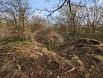
 Prodromia, as seen from Westwood. | |
 Flag | |
 Satellite view | |
| Established (original) | October 1995 |
| Established (modern) | 29 August 2018 |
| Government | |
| • King | Aggelos I |
| • Vizier | Lord Jonathan, Duke of Sweetpea Valley |
| Area | |
| • Total | 0.14301 km2 (0.05522 sq mi) |
| Population | |
| • Total | 0 |
| Time zone | UTC+1 |
The Kingdom of Rushymia is an uninhabited Crown Dependency of the Empire of Austenasia ruled directly by the Austenasian Monarch in their role as King of Rushymia. Rushymia claims legal continuity with a micronation of the same name which existed from 1995-2000.
Etymology
The name Rushymia is a portmanteau of "Rushy Meadow", the name of the primary school at which the original iteration of the kingdom was based. The name is customarily assumed to have been created by General James upon Rushymia's founding in October 1995 to designate the realm over which he had taken military control, but alternative traditions state that the polity had simply been known as "the Playground" until the coronation of King Billy in September 1997, when the name of Rushymia was created to give a more dignified appellation to his kingdom.
History
Rushymia was a non-sovereign micronation existing in the playground of a Carshalton primary school between 1995 and 2000, which transitioned from a military dictatorship to a monarchy in late 1997. Upon the abdication of King Alex (r. 1997-2000), he decreed that his legitimate successor would be the first person to retrieve a plastic bottle which he lodged high in a fence. None of his former subjects were able to achieve this feat, and so government of Rushymia quickly collapsed. A decade later, on 17 October 2010, the bottle was finally retrieved by Esmond III of Austenasia, who claimed the title King of Rushymia and so united the legal right to the crown of Rushymia with the Austenasian Throne.
For several years, the Emperors of Austenasia did nothing with their legal right to the Rushymian crown other than bestow various associated ceremonial titles. However, on 31 October 2017, the Parliament of Austenasia passed the Rushymia Act 2017, authorising the Monarch to make use of his title of King of Rushymia and claim an area of land on which to refound the kingdom as an Austenasian Crown Dependency. On 7 April 2018, notices were placed around an unused area of land in the United Kingdom under a mile from Wrythe announcing the intention of the Austenasian government to claim the land as a new site for Rushymia should no objections be raised.
No responses or objections were received from the notices, and so Emperor Jonathan I claimed the current site for Austenasia as the new location of Rushymia by an Imperial Edict on 29 August 2018. As 29 August is the feast day of the Beheading of John the Baptist, Jonathan I named St John the Baptist as patron saint of Rushymia.
On 15 May 2021, Jonathan I appointed Fabian Sapong as Vizier of Rushymia, to act as his viceroy and administer the kingdom in person. Sapong thereby became the first person to hold said office as anything more than a ceremonial title in more than two decades, but eventually fell out of contact with the King. Upon the abdication of Jonathan I in September 2024, his successor Aggelos I soon appointed him Vizier, to rule over Rushymia in his name as viceroy.
Government
Rushymia is an Austenasian Crown Dependency, and as such - although it is under Austenasian sovereignty and has no independent foreign or military policy - it is completely autonomous from the central government. Crown Dependencies fall under the absolute rule of the Monarch, who is generally represented by a Governing Commissioner; Rushymia is unique in that it is ruled directly by the Monarch as King of Rushymia. In the absence of the king, Rushymia is governed by his deputy, the Vizier of Rushymia. Two other titles - Warlord of the Playground and General of Rushymia - remain legally extant from the original kingdom and available for the King to bestow, but are currently vacant.
Geography
Rushymia measures roughly 35 acres, and is situated under a mile to the north-east of the Imperial Residence. It is located to the east of Beddington Corner,[1] to the south of Mitcham Common, to the west of Beddington Farmlands, and to the north of the BedZED housing development.
The legal status of the land prior to its annexation as Rushymia was somewhat murky. Although most likely owned by the company which operated a landfill site in the nearby Beddington Farmlands until the early 2000s, the land is unused for any industrial purposes and unmanaged by any parks or environmental services. It is often frequented by dog walkers, joggers, and amateur quadbike and moped drivers, who are easily able to access the land through large gaps in long-neglected fences.
Upon the passage of Imperial Decree XXXXI Jon. I on 29 August 2018, the land now constituting Rushymia was claimed as such. The three areas of Rushymia in a geographical sense were named Prodromia, Westwood, and Norfeorm, although these do not function as administrative divisions.
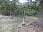
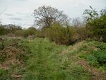
Prodromia
Prodromia is a large field measuring roughly 21 acres, comprising the north-eastern part of Rushymia. It was originally named by Emperor Jonathan I on 29 November 2014 as Filgert Field, to mark the 20th birthday of then-Austenasian politician Lady Evren Filgert, but was not claimed in any sense for Austenasia. It was renamed to Prodromia upon the annexation of Rushymia, in honour of the crown dependency's patron saint John the Baptist, also titled as "the Forerunner" - "ο Πρόδρομος", o Prodromos - in Eastern Orthodoxy.
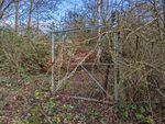
To the north, Prodromia is bordered by a fence, on the other side of which is Mitcham Common. This fence is in many places torn down, damaged, or missing altogether, and so the north of Prodromia is the main entrance to Rushymia as a whole. To the east, Prodromia is bordered by train tracks running from Peckham Rye to Sutton, and to the south by Norfeorm. To its west are two small industrial sites (as of October 2024, one hosts a demolition company and the other sells tyres and car parts), and to the southwest is Westwood.
The northern third of Prodromia was historically used by Beddington Corner football club as playing fields from the start of the 20th century up until the mid-1980s. The site of the pavilion used for the football club is not in Rushymia itself, but is now occupied by one of the aforementioned industrial sites.
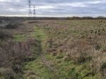
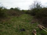
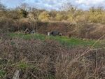
Prodromia has few landmarks as such, apart from two large electricity pylons to its south-east. It also features some raised areas of land topped with manhole covers. The main pathways on Prodromia follow the routes taken by quadbikers, and the site was named Biker's Field for this reason by a local birdwatching group. Other than the pathways made by quadbikers, most of Prodromia is covered in grasses, which can grow very tall in summer, as well as some patches of Rubus blackberry brambles. The remains of two cars[2] are also situated on Prodromia, one to the north-east and one to the south. Although small off-road vehicles such as quadbikes can access Prodromia, the great difficulty which would be involved in transporting two cars (presumably across Mitcham Common) to the site has been noted by visitors.
Prior to February 2017, when it was controversially demolished by Network Rail, a Victorian bridge spanned the railway track on Prodromia's eastern border, roughly a quarter of the way down from the north. Known as Hundred Acre Bridge, it was demolished to save on maintenance costs. However, a large mound of earth still exists on either side of the tracks where once the bridge stood.
-
Old fence posts marking the main entrance to Prodromia from Mitcham Common.
-
A gap in a fence leading onto Prodromia from Mitcham Common.
-
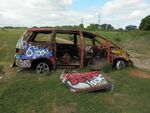
One of the two ruined cars in Prodromia.
-
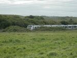
A train runs north along Prodromia's eastern border.
-
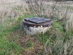
One of several mysterious manhole covers in Prodromia.
-
Looking south from the small hill on the former site of Hundred Acre Bridge.


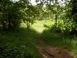
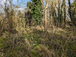
Westwood
Westwood is a wooded area measuring just under 7 acres, situated to the south-west of Prodromia and the north-west of Norfeorm. To its north are the two small industrial sites mentioned above, and to its west is a fence bordering the nearby main road in the UK.
The southern border of Westwood is marked by a water channel which discharges cleaned water treated by a nearby sewage works into the River Wandle. This waterway is culverted underground as it reaches Norfeorm.
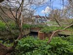
Much of Westwood is too thickly wooded to be accessible, with thick brambles and undergrowth preventing access even in winter through its north. The southern part of Westwood is somewhat less thickly wooded, and is accessible from a path that runs parallel to the water channel (and over a bridge crossing over it, as the water channel veers northwards at its western most point). The south-eastern part of Westwood is the most easily traversable part of the territory, with very few brambles between the trees.
Westwood as a whole has become more overgrown as time has passed; prior to 2015, all but its northern-most part was relatively easy to access, even in summer when brambles are at their thickest. This may be due to the closing of the main entrance to Westwood in early 2017, when an open space in the western fence (where the southern path led out on to the main road) was fenced up, as prior to this it was not uncommon to see members of the public in the area dog-walking or berry-picking in the summer. With far fewer people accessing Westwood, all but the main path have now become too overgrown to use.
Westwood is still accessible both at its south-eastern corner, where it borders Norfeorm, and usually also via a different hole further up in the western fence at the point where the water channel is culverted under the main road, although this is periodically (although, thanks to persons unknown, temporarily) closed by the British local council. Westwood is also notable for the number of abandoned motorcycles left in the area.
Satellite imagery from the 1940s shows that the southern part of Westwood was once cleared and in use for some purpose, with a large path or similar feature visible. This may be the origin of the "Gate to Nowhere", an otherwise mysterious blue metal gate which stands isolated in southern Westwood, as well as a nearby small building overlooking the waterchannel fenced off and boarded up in 2021.[3]
Another feature in Westwood of interest is the Regnal List. This is a list of ciphers carved into a tree (continuing a Carshaltonian tradition from the Midget Empire and from Copan) listing the two original kings of Rushymia and the four subsequent Austenasian emperors who have held that title.[4]
-
The main pathway through Westwood.
-
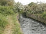
The water channel forming Westwood's southern border.
-
The "Gate to Nowhere".
-
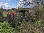
The boarded up derelict building overhanging the waterway.
-
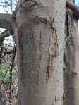
The Westwood Regnal List prior to the addition of the cipher of Aggelos I.
-
A hole in Westwood's western fence allowing access.


Norfeorm
Norfeorm is named after North Farm, a small farm which, according to historical maps, used to exist in the north-western corner of this part of Rushymia (fl. 1894-1949).[5] No obvious trace of what appears to have been a small farmhouse now remains above ground; although there are some scattered piles of bricks and masonry, these are difficult to distinguish from other such features to be found around Norfeorm.
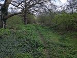
Norfeorm measures just over 7 acres. A path runs from the north-western corner of Norfeorm, where it adjoins Westwood and Prodromia, and runs south down its western border, parallel to a dry drainage channel (the actual border itself). Norfeorm is situated directly south of Prodromia, and so is bordered by the same train tracks to the east. To the south of Norfeorm is BedZED, and to the west - on the other side of the drainage channel - is open land near a school.
Other than the path running down its western border, much of Norfeorm is inaccessible due to trees and brambles, which get much denser the farther south one goes. There are two clearings in Norfeorm which can be accessed from the path. The second - which is only accessible in winter due to bramble growth at other times of the year - is sometimes used as a campsite by persons unknown.
The southern border of Norfeorm is formed by the southern most of two parallel dry drainage channels that run roughly perpendicular to the one that forms its western border. At the south-eastern corner of Norfeorm, a tunnel runs under the railway line, connecting the channel that forms the southern border of Norfeorm to its continuation in Beddington Farmlands. This is not considered a safe entrance into Norfeorm, however, which is accessible either at its north-western corner where the main path begins, or in its south-west heading north from BedZED.
Due to its overgrown nature, and the dangers inherent in a landscape with open drainage channels, it is very uncommon to encounter any members of the British public in Norfeorm.
-
The main path running along Norfeorm's western edge.
-
The first main clearing in Norfoerm.
-
The second main clearing in Norfeorm, used as a camp.
-
The densely wooded southern part of Norfeorm.
-
The slightly less densely overgrown northern part of Norfeorm.
-
The tunnel under the railway line.


Notes
- ↑ Of the various unofficial terms used locally to refer to this area, Beddington Corner is the most common, although it is also known as Mitcham Junction and/or the Goat. All three names are used somewhat interchangeably, with the exact location being referred to by each name changing depending on who is asked. "Place naming at this point is indeed very confused, since this part of Beddington became part of Wallington when the parish was formed in 1887; Hackbridge, also with no official existence, merges with Beddington Corner on the south; and the nearby Mitcham Junction station (over the borough boundary) gives a postal district name to this part of the London Borough of Sutton" (The London Encyclopaedia, Hibbert et al, 2010). The Austenasian Ministry of Defence officially considers the area as a part of Hackbridge.
- ↑ Both burnt, presumably having been involved in a crime and then destroyed.
- ↑ This small derelict building was previously accessible, and was used as a film set for the Colin "minisode" of Cool Barbie in 2015.
- ↑ "BR" and "AR" for "Billy Rex" and "Alex Rex", followed by "EI", "DI", "JI" and "AI" for "Esmond Imperator", "Declan Imperator", "Jonathan Imperator" and "Aggelos Imperator".
- ↑ A small building is mapped in the same place on an Ordnance Survey map surveyed 1866 to 1867, but is unlabelled.