Transport in New Eiffel
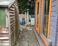
Transportation in the small European micronation of the Principality of New Eiffel was a significant industry consisting of cycling, walking and driving a motor vehicle. Due to the micronation's small size, cycling was the most represented mode of transportation, with New Eiffel having a cycle network consisting of 82 metres (271 feet) of cycle road across five designated roads. The New Eiffel Main Route 1 was the longest, most traversed and only fully paved road in the principality. Pedestrians were de facto allowed to walk on cycle roads as they could walk on streets, of which there were nine covering every section of road in New Eiffel. A tenth, Worker's Street, was the only not located on a road. Seat Square was the only public square in the micronation, although other public spaces like the Rugbull Field and New Eiffel Gardens existed instead. New Eiffel had two border crossings and no motor road network other than a single driveway, as well as a single car owned by the royal family. Management of transportation in the micronation was the responsibility of the Ministry of Transportation.
Management
The Ministry of Transportation (MoT) was the ministry responsible for all modes of transportation and their administration, including road, street and alleyway designations and maintenance, signage, traffic laws, and the New Eiffel Roads Index, which listed basic information on each of the roads and their statuses. Zabëlle Skye, Prince of New Eiffel between its foundation on 11 August 2018 and 20 June 2020, served as the minister of transportation between the position's creation on 12 February 2019 and New Eiffel's dissolution on 1 November 2020.
Cycle network
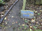

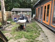
New Eiffel's total cycle network consisted of 82.76 metres (271 feet) of cycle road, of which 28.07 metres (92 feet) were paved and 54.69 metres (179 feet) were dirt roads. The cycle roads of New Eiffel were significant for allowing the transportation of supplies, building materials and heavy machinery from New Leeds, the largest and only populated city of New Eiffel, to the capital Új Repülő. Recreational cycling was also important to most New Eiffelians. Though supposed for cycling, the roads were commonly walked and also traversed by other forms of human-powered transport, including wheelbarrows, hand trucks and scooters. New Eiffel had five designated cycle roads—the New Eiffel Main Route 1 (NEMR 1), Dead Tree Lane, J16, J25 and Prince Zabëlle I Road.
The NEMR 1 was the longest, most traversed and only fully paved road in the micronation. Dead Tree Lane was partially paved while the J16, J25 and Prince Zabëlle I Road were entirely unpaved. All roads in the micronation possessed a code under the New Eiffelic Road Numbering System (NERNS), a program by the Ministry of Transportation. There were two junctions in New Eiffel—Triple Junction, an uncontrolled intersection, and Unnamed Circle, a raindrop roundabout. Although vehicle registration plates were legally required since 23 April 2019, no bicycle was ever registered. His Royal Mail Service of New Eiffel, New Eiffel's national package delivery and mail service, had planned to deliver via the cycle network. N.B.R. Bike Parking, south of the Rugbull Field, was the only bicycle parking lot in the micronation.
List of roads
| Road name | Length | Code |
|---|---|---|
| Dead Tree Lane | 6.98-metres (22.9 ft) | 03f |
| J16 | 23.6-metres (77 ft) | 01f |
| J25 | 6-metres (19 ft) | 05f |
| New Eiffel Main Route 1 | 42.8-metres (140 ft) | 02f |
| Prince Zabëlle I Road | 3.38-metres (11 ft) | 06f |
Motor network
Due to the micronation's small size, New Eiffel had no motor road network other than a single driveway. A single car, a 2016 Discovery 4 Land Rover Discovery, was owned by the royal family, who used it to transport the residents of New Eiffel where needed. Prior to 2 May 2019, they owned a 2006 Mark 1B/Phase 1.75 Volkswagen Sharan. It was parked in XCUT Therapy Parking, a motor parking lot which had four parking spaces.
Pedestrian network

Pedestrians were de facto allowed to walk on cycle roads as they could walk on streets. Nine streets covering every section of road in New Eiffel were designated by the Ministry of Transportation between 28 December 2019 and 10 March 2020. A tenth, Worker's Street, was designated in Seat Square on 12 May to honour the working class, and was the only street in the principality not to be located on a road. Seat Square in New Leeds was New Eiffel's only public square, housing Smith Restaurant—the only restaurant in New Eiffel—XCUT Therapy, a privately-owned events venue and a portion of New Eiffel Gardens. Seat Square was the most popular location in New Eiffel for social gatherings, especially barbecues and celebrations during public holidays in the micronation. New Eiffel also had three alleyways—New Leeds Alley in north New Leeds, South Alley in south Új Repülő and Walkway Alley in northwest Új Repülő. However, only New Leeds Alley was widely used. New Eiffel Gardens was a public garden.
List of streets
ǃkhās Street in Új Repülő was the most significant street, housing New Eiffel School, Jimbo's Gym and a privately-owned shed. The longest street was Norton Street at 20.5 metres (67.2 feet), comprising the NEMR 1's entire length in Plitvice. Northwest Street in Dead Tree Lane was the shortest at 2.51 metres (8.2 feet). The NEMR 1 had the most streets, four, while Dead Tree Lane had two. Prince Zabëlle I Road, the J16 and J25 each had only a single street, comprising their entire lengths. Three streets were named after individuals—Norton Street after Emperor Norton, Randouler Street after Nicholas Randouler, and Smith Street after the Smith ruling house. Seat Square was formerly designated as a street between 28 December 2019 until being re-designated as a public square on 9 February 2020.
| Street | Designated | Length | Road |
|---|---|---|---|
| Dead Tree Street | 10 March 2020 | 4.47-metres (14.6 ft) | Dead Tree Lane |
| Diamond Street of the Esteemed Gems | 10 March 2020 | 3.38-metres (11 ft) | Prince Zabëlle I Road |
| Gæ Pis Street | 26 February 2020 | 4.20-metres (14 ft) | New Eiffel Main Route 1 |
| ǃkhās Street | 28 December 2019 | 11.8-metres (38.7 ft) | New Eiffel Main Route 1 |
| Northwest Street | 10 March 2020 | 2.51-metres (8.2 ft) | Dead Tree Lane |
| Norton Street | 10 March 2020 | 20.5-metres (67.2 ft) | New Eiffel Main Route 1 |
| Randouler Street | 10 March 2020 | 6-metres (19 ft) | J25 |
| Smith Street | 10 March 2020 | 23.6-metres (77 ft) | J16 |
| Új Repülő Street | 9 February 2020 | 4.40-metres (14 ft) | New Eiffel Main Route 1 |
| Worker's Street | 12 May 2020 | 3-metres (9.8 ft) | — |
Border crossings
As a landlocked micronation within the United Kingdom, New Eiffel shared 156 meters (511 feet) of borders with England and two border crossings. Shaped like a near-perfect rectangle, New Eiffel had four borders named by the four cardinal directions (points of the compass), three of which had border barriers for their entire lengths. The New Eiffel–United Kingdom East Border was the most frequently crossed border with approximately 950 to 1,300 documented crossings annually. The New Eiffel-United Kingdom West Border, colloquially the "back border," was a heavily fortified border with less than approximately 20 to 45 documented crossings annually. The New Eiffel–United Kingdom North Border and South Border were adjacent to private properties in the surrounding London, thus making them uncrossable.
