Gardiner Railway
| Gardiner Railway | |
|---|---|
 Aerial view of Kingsford Station, looking south-west. | |
| Locale | Gardiner, MGPRA1 |
| Click here | |
| Preserved operations | |
| Operated by | Gardiner Railway Commission |
| Stations | Three (one proposed) |
The Gardiner Railway is a model railway running in the A1 protectorate of Gardiner, moving passengers and goods throughout the protectorate.
Infrastructure
The railway is serviced by HO scale model tracks and rolling stock. The network is at ground level, but also includes three tunnels, three stations and six bridges.
Trains are controlled from a central control panel, which can operate switches remotely, via a visual representation of the railway network. Train speed and direction is also controlled from this panel, by separating the network into sectors in which the current can be controlled.
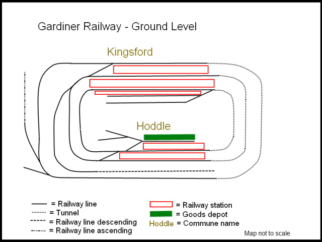
Sidings for storage and shunting of rolling stock are present at all four stations, however Hoddle Station has the most extensive and suitable shunting yards for these purposes.
Rolling stock
(See main article: Gardiner Railway rolling stock)
There are five types of engines currently in service. One of these is exclusively for passenger trains, two can be used for either goods or passenger, one is exclusively for goods trains and another is exclusively for shunting, recovery and short-haul purposes.
Lines
Kingsford-Hoddle Loop
The double-track Kingsford-Hoddle Loop is the most frequently used line on the network. As its name suggests, trains on this line, mostly passenger, run in a continuous loop from Kingsford to Hoddle stations.
Tourist Route
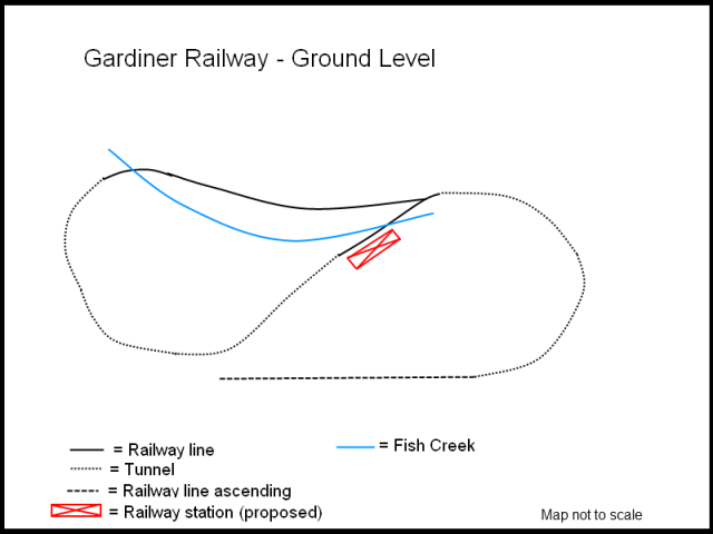
The single-line Tourist Route runs from Platform 2 of Kingsford Station, descends via a tunnel into the ravine with Fish Creek in it, completes the loop and returns to Kingsford Station. Only one train is permitted on the line at any one time so as to avoid collisions.
Mount Harwick-Hoddle
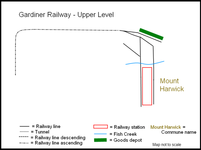
The single-line route is mostly used be freight trains moving minerals down from the Mount Harwick Mines to Hoddle for storage and subsequent removal. The line is mostly on a rise following much of the boundary of the protectorate, and terminates at Platform 1 or Siding 1 at Hoddle Station/Shunting Yards.
In some cases, however, the train may stop at Kingsford also and leave some rolling stock behind, so as not to put too much pressure on the Hoddle Station yards.
Gardiner Railway Commission

The commission was established by the A1 Government's newly amalgamated Ministry of Communications & Transport on 14 May 2010 to manage and maintain the Gardiner Railway. It is a government owned and run entity, with the responsible minister being the Minister for Communications & Transport, Jane Hawley.
Accidents and mishaps
Mail Carriage Crash
During construction and testing of the railway, a train hauling a mail carriage for track testing was directed onto a sharp curve at too high a speed and subsequently, the carriage fell into Fish Creek near the base of Mount Harwick. The decision was taken by the A1 Government to leave the mail carriage where it fell as a reminder of the mishap.
The track upon which it was travelling was subsequently dismantled.
June 2010 Expansion Plan
In June 2010, the Ministry of Transport and Communications announced that an expansion plan over the course of 2010 and early 2011 would take place. The plan incorporates many upgrades of the Railway.
New station on Tourist Route
A new railway station is proposed to be built in the separating ravine, alongside Fish Creek. The station is proposed to serve as an observation and stopping point for tourist trains and their passengers. As space is limited in the area, owing to the rugged terrain of the Mount Harwick Lowlands, the station is proposed to be much smaller than other stations, and does not involve the laying of any extra track.
New rolling stock & engines
Owing to the dilapidated state of some engines and rolling stock, replacements are necessary. These replacements are expected to arrive and be in service by the end of 2010. It is anticipated that at least one new locomotive will be purchased for shunting and short-haul purposes.
Maps
Ground level (Kingsford & Hoddle)

Upper level (Mount Harwick)

Lower level
