Autoroutes of Los Bay Petros
| Federal Autoroute System | |
|---|---|
 The autoroute shield. | |
| Total length | 300 km |
| Longest highway | Autoroute 3 (150 km) |
| Shortest highway | Autoroute 629 (600m) |
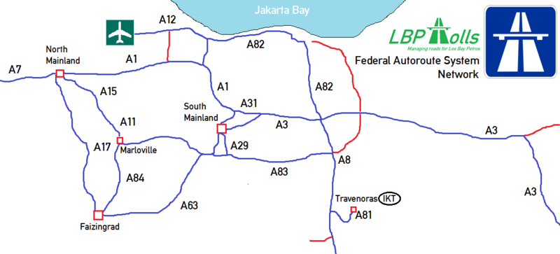
The expressways that connected in Federal Republic of Los Bay Petros is called Autoroute (officially Federal Autoroute System). The Los Bay Petrosian Autoroutes network length is estimated about 300 kilometres. Firstly, this autoroute was proposed by Adriansyah Yassin Sulaeman to facilitate the Los Bay Petrosian who travels around the country.
History
The Autoroute was first proposed by president Adriansyah Yassin Sulaeman to the National Legislative Council in 2010, the reason was to simplify the Los Bay Petrosian people or non-Los Bay Petrosian to travel without any obstacles like traffic jams in the Jakarta's rush hour and other, this project also intended to relieve the Los Bay Petrosian economy since the civil war.
The project finnaly passed by the National Legislative Council and the project to make the

routes of A-1 ( Autoroute 1 ), which connecting Dredim and Gordonz City began in late February 2010. The project of A1 finally finished in mid-March.
Since the foundation of Southall and Dalnik, the government also continuing to lengthened the network, finally they made the A17 (Autoroute 17) connecting Southall and New Pershing City, A21 which connecting Southall and Dredim, and the A-6 which connects Dalnik City and Faizingrad.
System
All of the Los Bay Petrosian Autoroutes is managed by LBPTolls.inc, and all of the Autoroutes is

tolled. and there is no prohibition on motorcycles who wants to enter the Autoroute, not like Indonesian toll roads who prohibit motorcycle to enter the toll road.
In the toll plaza or toll booth, there are three groups of transportations with the different fare each group. they are:
| Category | Vehicles |
|---|---|
| 1 or A | Motorcycles Tuk-Tuks |
| 2 or B | Sedan Minivan Taxis Pick-ups |
| 3 or C | Trucks Bus Trailers |
And for the payment itself, the drivers can pay both in Los Bay Petrosian Ruble and Indonesian Rupiah.
Standards
Standards for Autoroute Expressways in Los Bay Petros are defined by the Los Bay Petrosian Ministry of Transportation along with the LARO (Los Bay Petrosian Autoroute Association. For a certain highway to be considered an Autoroute, it must meet these construction requirements or obtain a waiver from the Federal Autoroute System.
- Speed Limits: The minimum speed limit standard in Los Bay Petros is 140 km/h in rural areas or selected urban area, an advisory of 130 km/h in Southall Autoroutes, 110 km/h in tunnel and briges, and 90 km/h in mountanious areas.
- Minimum number of lanes: At least two lanes in each direction, this standard could be an exception in some parts of the system.
- Payment system: Tolling system in the autoroute is optional, but recommended.
- Median type: To meet the requirements, the Los Bay Petrosian Autoroute median type should be built in Constant slope barrier or Cable barrier type.
Numbering Scheme
This is the numbering system in the Los Bay Petrosian Autoroutes.

Digit 1-10
| Autoroutes | Terminus 1 | Terminus 2 |
|---|---|---|
| A1 (Autoroute 1) | Dredim Capital Region | Gordonz City |
| A2 (Autoroute 2) | Prianganstadt Nord | Panghegar |
| A3 (Autoroute 3) | Dredim Capital Region | Prianganstad Nord |
| A4 (Autoroute 4) | Sultan Hasanuddin Airport | Dwipatra, Ostenkass |
| A6 (Autoroute 6) | Faizingrad | Dalnik City |
| A8 (Autoroute 8) | Dredim | Gunung Jaya Utara, Gunung Jaya |
Digit 11-99
| Autoroutes | Terminus 1 | Terminus 2 |
|---|---|---|
| A11 (Autoroute 11) | Marloville, Salernosky | Kunciran, North Salernosky |
| A12 (Autoroute 12) | Autoroute 1 Tomang Interchange | Soekarno-Hatta International Airport |
| A13 (Autoroute 13) | Dredim | North Labstadt University |
| A14 (Autoroute 14) | East Salernosky | Labstadt |
| A15 (Autoroute 15) | Kunciran, North Salernosky | Blueing, Western Los Bay Petros (Interchange with A1) |
| A17 (Autoroute 17) | Faizingrad | New Pershing City |
| A18 (Autoroute 18) | Faizingrad | Outer Southall |
| A21 (Autoroute 21) | Dredim Capital Region | Southall (Via Fatmawati) |
| A29 (Autoroute 29) | Dredim Capital Region | Gordonz City |
| A36 (Autoroute 36) | Dredim Capital Region | Newlam |
| A63 (Autoroute 63) | Dredim Capital Region | Southall (Via Fatmawati, merged with A29 at Lebak Bulus) |
| A81 (Autoroute 81) | A-8 Interchange | Jumstraad, Indokistan |
| A84 (Autoroute 84) | Faizingrad | Labstadt |
| A94 (Autoroute 94) | New Pershing City | Dagen-Madinah |
Digit 100-999
| Autoroutes | Terminus 1 | Terminus 2 |
|---|---|---|
| A126 (Autoroute 126) | Dredim | New Pershing City (Via JORR) |
| A629 (Autoroute 629) | Labstadt | Labstadt (Orbital Ring) |
| A631 (Autoroute 631) | Arutalapura | Arutalapura (Orbital Ring) |
Auxillary Routes
| Autoroutes | Terminus 1 | Terminus 2 |
|---|---|---|
| A1-001(Dredim Orbital Expressway North) | Dredim, Killarney | Dredim, Charleston (Via Park) |
| A1-002 (Dredim Orbital Expressway South) | Dredim Capital Region, Diningrad | Dredim, Charleston |
| A1-003 (Dredim Orbital Expressway 2) | Dredim Capital Region, Diningrad | Dredim, Sega Park |
Unnumbered Autoroute
| Autoroutes | Terminus 1 | Terminus 2 |
|---|---|---|
| FRR (Faizingrad Ring Road | Faizingrad, Warren Beach | Ringroad |
| Karawaci Causeway | Gordonz City | Autoroute 6 |
| DRR (Dalnik Ring Road) | Dalnik City, Matlock | Dalnik City, Wanderer |
| CR (City Ring) | Relofsy, Gaskan | Walton, New Pershing |
| L Expressway | Kingsley, Dredim | New Pershing City |
| KBP (Killarney Baypass) | Killarney, Dredim | Charleston, Dredim |
Tanah Baruan Autoroutes
In the state of Tanah Baru, the Federal Autoroute Network there uses a special signgage for all of the autoroutes, a -M ending in all routes.
Facts
There are some facts in the Autoroutes of Los Bay Petros, they are:
- Longest Autoroute: Autoroute 3 (Prianganstad Nord - Dredim), 150 km

A3 - Shortest Autoroute: Autoroute 629, 0.6 Km
- Highest Autoroute: Autoroute 3 (Priangantstad Terminus), 100m above sea level
