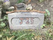
J25
| J25 | |
|---|---|
 The J25 road marker | |
| General information | |
| Maintained by MOT | |
| Length | 6-metres (19 ft) |
| Existed | January 2019–1 November 2020 |
| Intersections | J16 |
| Location | |
| Nation | |
| City | |
| List of roads in New Eiffel | |
The J25 — designated 06f under the New Eiffelic Road Numbering System (NERNS)[1] — was a short, roughly 6-metre (19 ft) long bicycle road in southwest Plitvice, in the erstwhile Principality of New Eiffel. Splitting from the J16 near N.B.R. Bike Parking and immediately terminating back into it, the J25 served as a diversion to a portion of the J16 — the J25's namesake — after a part of said road had become flooded and turned into a muddy slope. Built from a pile of dirt, the road elevated some 325 millimetres (12.7 inches). The roadway existed between January 2019 and 1 November 2020, becoming completely disused by the dissolution of New Eiffel. After the territory was seceded to the Grand Duchy of Australis, the roadway was not re-designated. The J25 comprised one street, Randouler Street (formerly La-la-lee Street), which was designated on 10 March 2020.
Route description

The J25 was located in southern Plitvice, and had a length of roughly 6-metres (19 ft). Splitting from the J16 just south of the J25 road sign near potted plants fronting N.B.R. Bike Parking, the J25 curved south before assuming a westerly course. Fronting the New Eiffel-United Kingdom South Border to the south, and the rugbull field to the north, the J25 traveled towards Plitvice Bomb Shelter, before curving north and merging (terminating) back into the J25.[2][3] The J25 elevated about 325 millimetres (12.7 inches).
History
Background
In January 2018, the J16 was the most frequently used road within the Republic of New Finland—the predecessor to the Principality of New Eiffel. Due to the roadway having a lowering slope at an area just east of Plitvice Bomb Shelter, the slope would become flooded whenever it rained heavily. This continued throughout early 2018, causing the J16 to subsequently become permanently muddy and thus hazardous to cyclists. The condition of the J16 continued to worsen within the succeeding months, with the state of the J16 so poor that the slope became a primary filming location for the battlefield in Z&jProductions' The Great War Part I, a film about World War I, released on 12 April.[4]
Formation of the J25
In early May 2018, a deceased flowerbed south of the slop of the J16 was removed, which cyclists then began using as a diversion to avoid cycling over the muddy slope of the poorly maintained roadway. In October, a pile of dirt was poured onto the unofficial route by the landowner. As the route was not an officially designated road, the cyclists were unable to legally protest against it, and were subsequently forced to reuse the J16.[5] Although the grass on said road had since regrown, the frequent usage by cyclists resulted in the J16 once again turning into a muddy slope by November. In January 2019, the Minister of Transportation, Zabëlle Skye, received permission from the landowner to convert the pile of dirt into a roadway, which was to be designated the J25. That same month, Janus Smith converted the dirt pile into a flat and rideable surface, and in February the road became the first in New Eiffel to have a separate road marker.[a]
Disestablishment
Due to the roads elevation of some 325 millimetres (12.7 inches), it slowly crumbled throughout its frequent usage between February and May 2019, although its usage would gradually decline afterwards. In May, more dirt was added in order to help with its crumbling, however this inadvertently had the effect of making it crumble faster due to the dirt being lose. By July, the roadway was nearly entirely unused as it was seen by cyclists as hazardous. In January 2020, the Ministry of Transportation decided to level the J25 in order to solve this problem. The levelling took place between 19–25 January, however it ultimately proved unhelpful in increasing the J25's usage. On 10 March, La-la-lee Street was designated on the route, being proclaimed by the Minister of Transportation. On 13 June, the street was renamed to Randouler Street, in honour of micronationalist Nicholas Randouler who had died several days earlier.[6] Following the dissolution of New Eiffel on 1 November,[7] the roadway lost its designation, and when the former territory of New Eiffel—including that of the J25—was seceded to the Grand Duchy of Australis on 12 January 2021, the roadway was not re-designated.
Usage
According to the Ministry of Transportation, the J25 was the third (of five) most used road in New Eiffel in 2020, having been cycled on 116 times.[8] The J25 served as a diversion to a portion of the J16 after a part of said road had become flooded and turned into a muddy slope. Used unofficially between May and October 2018 over a former deceased flowerbed, the roadway became a commonly used diversion by cyclists. After a pile of dirt was poured onto the area in October by the landowner, the cyclists were unable to legally protest against it, and were subsequently forced to reuse the J16. When the road was officially designated in January 2019, the J25 became prominently used as an alternative route, with some cyclists even travelling the J16 specifically to ride the J25 as a recreational route. Its elevation made it a "novelty" road to cyclists. After the roadway began crumbling in July, it became entirely unused due to being seen as hazardous.
Intersections
The J25, which split-off from the J16 and immediately led back into it, was used as a diversion to the aforementioned road after a part of it had become flooded.
| m | ft | Road | Code |
|---|---|---|---|
| 0 | 0 | → |
01f |
| 6 | 19 | → | |
| 1.000 m = 3.280 ft; 1.000 ft = 0.304 m | |||
See also
Footnotes
- ↑ Dead Tree Lane had a road sign, placed in October 2018.
References
- ↑ Designated roads under the New Eiffelic Road Numbering System. New Eiffel Roads Index. Ministry of Transportation. Retrieved 26 September 2022.
- ↑ "Plitvice" (map). New Eiffel Maps. 1:50,000. First Series. Government of New Eiffel. August 2019. Retrieved 21 March 2021 – via the Royal Archives.
- ↑ Skye, Zabëlle (10 May 2019). Video of the J25 (video). Royal Archives. Retrieved 26 September 2022.
- ↑ Skye, Zabëlle; Smith, Janus (12 April 2019). The Great War Part I (motion picture). Z&jProductions. Retrieved 26 September 2022.
- ↑ Image gallery of the J25. Royal Archives. Image 3. "The dirt pile was placed by the landowner in October 2018. This went without protest as the path was at this time not yet formally designated." Retrieved 22 April 2021.
- ↑ Streets. New Eiffel Roads Index. Ministry of Transportation. Retrieved 26 September 2022.
- ↑ Valentinus, Sertor (1 November 2020). "Principality of New Eiffel declared dissolved". The Brookside Gazette. Retrieved 26 September 2022.
- ↑ Skye, Zabëlle (5 January 2021). "Road traffic in New Eiffel for the year 2020" (report). Ministry of Transportation. Retrieved 26 September 2022 – via the New Eiffel Roads Index.


