Hilda River
Jump to navigation
Jump to search


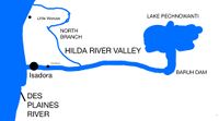
The Hilda River is a river in southern Hilda in southern Wegmat. It travels from a runoff basin to the Des Plaines River the River is dammed at the Baruh Dam which forms Lake Pechnowanti. The dam is made of dirt and is used as a bridge for Route Connection 14. The Hilda River splits into two branches; the north branch runs towards and under the Canadian National railway through Bailey National Forest and ends just past the railway. The main branch passes through Isadora and pours into the Des Plaines.