Golfia
Golfia | |
|---|---|
| Golfia Autonomous Province | |
 | |
| Country | |
| Established | 10 December 2020 |
| Capital | Boundary City |
| Government | |
| • Type | Associated state |
| • President | Riley S. (D) |
| Population | |
| • Total | 7 population as of 2,023 |
| • Rank | 1st |
| Demonym | Golfer |
| Postal Abbreviation | GAP |
| Official language(s) | English |
| Area | 192 Acres |
| Legislature | Board of Commisioners of Cook County |
Golfia is an autonomous region in the Federal Union of Wegmat. Golfia is part of the In-Provinces area, meaning it is in the general area of Two Pine. Golfia became a Province as protest to a road being expanded, removing several trees.
Geography
Golfia is located on the Golfia Gap, a large expanding area of low lying plaines. Golfia borders the USA on the east and west side. Golfia’s west border is the Des Plaines River. Golfia borders Whynofly to the Northwest, Drystone to the Northeast and Hydrove to the South. In the Southeast of Golfia is the Provincial Forest which is a large closed off forest that makes up 15% of Golfia’s land.

Cities
- Boundary City
- Walsh
- Lakeland
Culture
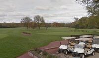
Golfia is named after the National Golf Course, which makes up 80% of it’s land. Golfia is responsible for housing the Wegmat Headquarters of the CCFPD. Golfia’s culture is based off of golf as the National Golf Course (also named Indian Boundary Golf Course) is the most popular golf course owned by the CCFPD.
Economy
Golfia’s entire economy is based off of purchasing tee times in the Golf course. It is the most profitable business in Wegmat. The CCFPD uses this money and taxes from Cook County to maintain trails and some public facilities in much of Wegmat.
