Bayrschtein Capital Territory
| Bayrschtein Capital Region Байpштей столичный регион バイエルンシュタインの首都圏 | |
| |
 Flag of Bayrschtein | |
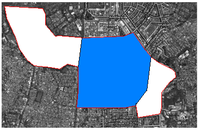 Location of region within Los Bay Petros | |
| Full Name | Bayrschtein Capital Region |
| Capital | Bayrschtein Capital Region |
| Established | February 18th 2010 |
| Area | 2700 sqm |
| Population | 9 |
| License Plate code | 1 |
| Government | |
| Type | Special Direct Region |
| Leader(s) | Mayor Adriansyah Yassin Sulaeman |
| Divisions / Counties | 15 |
| NLC Seat | |
| State Representative from | Civil's Welfare Party |
Bayrschtein, officially known as the Bayrschtein Capital Territory (Indonesian: Daerah Ibu Kota Bayrschtein), formerly Dredim, is the capital of Los Bay Petros. Located on the southern region of Jakarta, Bayrschtein is the country's economic, cultural centre, while the political centre is located in Labstadt. Bayrschtein is the one of two special regions in Los Bay Petros. With area of approximately 2700 sqm, Bayrschtein is the largest city in Los Bay Petros.
Established in 2010, the city is the Los Bay Petrosian plan to relocate after the Los Bay Petrosian Civil War. The city also felt the anti-separatism war against Republic of Shuffle.
The city is the seat of the TASPAC and Association of Indonesian Micronations secretariat. Bayrschtein is served by the Adji Rizqi Bayrschtein Intermicronational Airport, Adriansyah Yassin International Airport, Pierson Regional Airport, and it is connected by several intercity expressways, and served by several bus lines and a metro.
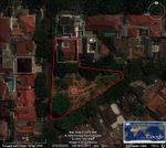
Bayrschtein is located in the Kebayoran Baru district, Jakarta. Bayrschtein is located 2 kilometres from Labstadt and 35 kilometres from Newark City.
History
On February 12 2010, Adriansyah Yassin Sulaeman thinking about moving the capital city from Newark to Dredim (Bayrschtein) after the devastating Civil War aftermath. With the minister of future

developments on that time, Raka Hadhyana, they planning to move the city to Dredim, approximately 30 kilometres southeast from Newark City. After a several meeting with the cabinet member and they ratified it, they're accepted the project.
Soon after the foundation of Bayrschtein, the presidential palace also moved to the new complex in Allevon district. Soon after the foundation of the city, Adriansyah Yassin Sulaeman stated that they has annexed a new 1800 square meters land south of DCT. This new territory named Sega Park. The expansion continued after the Ministry of Future Developments signed the proposal to annex a more bigger territory. The NLC calculate the area and the new territory area is 0,5 kilometre square and consist of 6 new districts.
When the war erupts on April 28 2011, the Republic of Shuffle tries to annex the Vruel
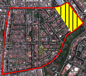
district or the northeastern part of Bayrschtein. There are still hostiles happen between LBPAF and the Shuffleian army there. But, after the massive attack conducted by LBPAF in the October 14th operation,[1] the Shuffleian Armed Forces began to decrease it's activities along the disputed border.
After the war ended, a year later, a referendum was held after some proposal was sent to the local government about the name Dredim is somewhat confusing for thr citizens. The referendum show results that the name Bayrschtein was preffered by the half of Dredim residents. By December 1, by an official determination papers from the government, the name of the Los Bay Petrosian capital city is changed to Bayrschtein.
Districts
Bayrschtein Capital Territory is divided into a 16-administrative subdivisions (also known as a district or precincts). Each of the district has one representative for the Local Government Council of Bayrschtein.
In March 2012, there's some name changing in several districts, including De Lepetav, Uqav, Yuroktak, and Mount Yimilbiçir. The list of the districts is shown below:
- Allevon
- Byankovo
- Charleston
- Diningrad
- Downtown
- Dunhill
- Haverpasst (Formerly De Lepetav)
- Killarney
- Kingsley
- Köstler (Formerly Uqav)
- Laji
- Lychen
- Mulach
- Mount Sedeçekdir (Formerly Mount Yimilbiçir)
- Sega Park
- Vruel
- Kovstretimsya (Formerly Yuroktak)
Transportation
There are some transportation systems that provided in Bayrschtein, including taxis (which originating from bordering Jakarta), an ojeks (A traditional motorcycle taxi in Indonesia), a Jakarta's Metro mini bus systems which has a route that passes both Bayrschtein and Labstadt, a Bajajs or Tuk Tuks, TransJakarta Bus Rapid Transit which has a bus shelter nearby the city and an undergoing project of Jakarta Mass Rapid Transit; a underground metro trains which estimated to be finished in 2015 or 2016. One of the stations in the original line, Blok A station, is located in the Southwestern Bayrschtein nearby the Bayrschtein and Labstadt border.[2]
While in Los Bay Petrosian government-funded transportation systems, Bayrschtein is served by several airports, a Shuttle car to Labstadt and Arutalapura, an inner transit system and a several Autoroutes that circles the city and connecting Bayrschtein with other Los Bay Petros. All of city's government-funded transportation systems is in authority of DCTA (Bayrschtein City Transportation Agency).
Air Transportation
The nearest operational international airport from Bayrschtein City is Jakarta-Soekarno Hatta International Airport, which is situated about 20 kilometers northwest from the city.
Meanwhile, the government of Bayrschtein operated 3 Intermicronational airports and a domectic airport. First, there is the Adji Rizqi Bayrschtein Intermicronational Airport who is the main airport in Bayrschtein area who served the intermicronational flights in Bayrschtein. The proposed location of Allevon is on the Allevon District, south from Downtown. The proposed airport facilities are 1 Heliport, 8 runways and 5 Passengger Terminals and a Cargo Terminal. The airport is the LBPair Main Hub.
Second, Adriansyah Yassin Intermicronational Airport serving for domestic flights from and to Bayrschtein. The proposed location of this airport is on the Dunhill District. The proposed airport facilities is a terminal with 2 runways. There's also an airfield in Bayrschtein, Killarney Airbase or Killarney Airfield who is a proposed airbase and the main headquarters of LBPAF-ADF. The airport is closed for public and being used only for government and LBPAF. Just like the name, Killarney Airbase was located in Killarney District.
Land Transportation
Expressways
Bayrschtein is served by several major Autoroutes criss-crossing the city. All of the Autoroutes in Bayrschtein are managed by LBPtolls.inc. There is also a speed limit that unofficially applied in Bayrschtein's road, 70 km/h in days whil 55 km/h in night.
- A-1 (Cross the Downtown Bayrschtein to Gordonz Autonomous Region)
- A2 (To Indrakonur)
- A3 (To Prianganstad)
- A8 (To Novayagrad)
- A1-001 (Cross the Northern Bayrschtein, to reduce Traffic jam on A1)
- A1-002
- A1-003
- A 126 (Cross the Southern Bayrschtein to New Persing & Gaskan State)
- A 21 (To Southall)
- A29 (To Gordonz City)
- A36 (To Newlam)
- A63 (To Southall)
- Killarney Bypass (Connecting the A 1-001,A1 and A 1-002)
Bus
Bayrschtein is also provides a intercity BRT network system (alongside TransJakarta), which is managed by the Vanderbilt Buses Corporation. Until March 2012, Bayrschtein Intercity buses provides 6 different routes criss-crossing the city.
The buses run along the following routes:
- Route 1(Kingsley - Dunhill)

Downtown Station - Route 2 (Kovstretimsya - Downtown)
- Route 3 (Charleston-Allevon Airport)
- Trans Airport Line (Route 4) (Allevon District - Dunhill District)
- Route 5 (Killarney - Mulach)
- City Ring Line (Route 6) (Killarney - City Park - AYA - Allevon - National Stadium - City Square)
Rail
Bayrschtein City has rail transit system circling the city and the DT (Bayrschtein Transit) is operated by DCTA. The DT currently operates 7 lines.
- Line 1 (Downtown - Allevon)
- Line 2 (Killarney - Adriansyah Yassin Airport)
- Line 3 (Downtown - Vruel)
- Line 4 (Downtown - Kovstretimsya)
- Line 5 (Express) (Vruel - Downtown - Adriansyah Yassin Airport)
- Line 6 (Haverpasst - Mount Sedeçekdir)
- Line 7 (Byankovo - Köstler)
Sports Team
Bayrschtein City has it own sports team,there are:
- Football (Soccer) - Bayrschtein Comets
- Baseball - Bayrschtein Smashers
- Basketball - Bayrschtein Knickers
Notable Places
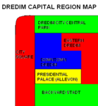
- City Square - A medium size square in the Kingsley, Mulach and Killarney District
- City Park - A medium size park in the Dunhill and Kingsley District
- Presidential Palace - On the Downtown District
- Backyard Stadt / 14 October National Stadium - A multifunction stadium.The main stadium of the Los Bay Petrosian National Football Team and the Dredim FK

14th October National Stadium - Scalzen Observatory - A small observatorium (only consisted a small telescope) in the north of city square
- Mamma's Bar - A famous restaurant in Charleston District
Notable Residents
- Adriansyah Yassin Sulaeman, the President of Los Bay Petros
- Muhammad Andy Rafly, the former Youth and Sports Affairs Minister and also the leader of Shuffleian separatist
- Abdi Rizqi Muharram , the former Health Minister
- Nafandra Lubis, the president of Republic of Islamkistan
Sister Cities
Border Checkpoint
Bayrschtein has 3 border checkpoints to Indonesia
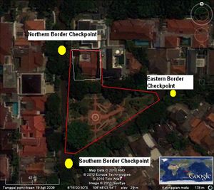
, they are:
- Northern Checkpoint
- Southern Checkpoint
- Eastern Checkpoint
Climate
| Bayrschtein Climate data | |||||||||||||
|---|---|---|---|---|---|---|---|---|---|---|---|---|---|
| Month | Jan | Feb | Mar | Apr | May | Jun | Jul | Aug | Sep | Oct | Nov | Dec | Year |
| Average high °C (°F) | 29.9 (85.8) |
30.3 (86.5) |
31.5 (88.7) |
32.5 (90.5) |
32.5 (90.5) |
31.4 (88.5) |
32.3 (90.1) |
32.0 (89.6) |
33.0 (91.4) |
32.7 (90.9) |
31.3 (88.3) |
32.0 (89.6) |
31.8 (89.2) |
| Average low °C (°F) | 24.2 (75.6) |
24.3 (75.7) |
25.2 (77.4) |
25.1 (77.2) |
25.4 (77.7) |
24.8 (76.6) |
25.1 (77.2) |
24.9 (76.8) |
25.5 (77.9) |
25.5 (77.9) |
24.9 (76.8) |
24.9 (76.8) |
25.0 (77) |
| Precipitation mm (inches) | 384.7 (15.146) |
309.8 (12.197) |
100.3 (3.949) |
257.8 (10.15) |
133.4 (5.252) |
83.1 (3.272) |
30.8 (1.213) |
34.2 (1.346) |
29.0 (1.142) |
33.1 (1.303) |
175.0 (6.89) |
84.0 (3.307) |
1,655.2 (65.165) |
| Avg. rainy days | 26 | 20 | 15 | 18 | 13 | 17 | 5 | 24 | 6 | 9 | 22 | 12 | 18 |
Gallery
-
The old flag of Bayrschtein (as Dredim) -
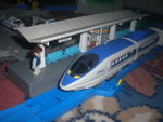
A train stops in
the DT line 1 -
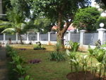
Killarney Park -
Killarneyplatz -
Bayrschtein territory between 2010-2011 -
Bayrschtein's tourist attraction map
References
