UP4 postcode area
The UP4 range (also known as Urabba Rear or Rear Urabba) is a range of Urabba Parks which borders an unnamed lane running parallel with Urabba Street, Rankins Springs, 2 and 6 Urabba Street and UP3 range.
Jurisdictional and administrative divisions
The entirety of the UP4 range sits within the Campus of Rankins Springs in the Flandrensian Ecological County of Urabba.
Postal administration

The UP4 range is located at the part of Urabba Parks that faces an unnamed lane running parallel with Urabba Street, Rankins Springs. The unnamed lane is not accessible by ordinary road vehicles, which should enter via Urabba Street. However the lane can be used by pedestrian traffic to access the Rankins Springs village. The micronational highway of Urabba Parks runs through UP4 as Willandra Gate.
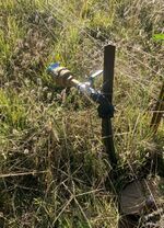
In October 2021, Carrathool Shire Council installed a potable water supply, known in Urabba Parks as the Urabbaparcensian Water Board in UP4, alongside the unnamed lane.
List of postcode districts
The approximate coverage of the postcode districts, with the historic postal district names shown in italics:
| Postcode district | Post town | Coverage | Local authority area(s) |
|---|---|---|---|
| 2669 UP4A | RANKINS SPRINGS | Willandra Gate, which connects UP3 and the unnamed lane running parallel with Urabba Street. | Campus of Rankins Springs |
| 2669 UP4B | RANKINS SPRINGS | Parts of UP4 not falling in another range | Campus of Rankins Springs |
| 2669 UP4W | RANKINS SPRINGS | The Urabbaparcensian Water Board | Campus of Rankins Springs |
Area and boundaries
The UP4 range comprises approximately 25% of the territory of Urabba Parks (327.5 metres). The area is bounded by Urabba Square in UP3 to the west, 2 Urabba Street to the south, 6 Urabba Street to the north and the unnamed lane running parallel with Urabba Street to the east.[1]
There is a fence between the part of the boundary with UP3.
References
- ↑ Plan of boundary remarking of 4 Urabba Street, Rankins Springs. PHL Surveyors, Griffith NSW. Dated 28 April 2017.