Islas Exteriores Province
Islas Exteriores Province | |
|---|---|
| Provincia de Islas Exteriores | |
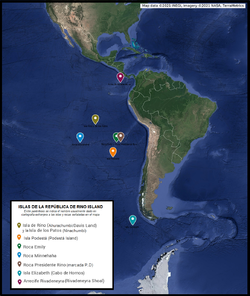
 Map of the islands of the Province of Isla Rino and Islas Exteriores. | |
| Country | |
| Government | |
| • President | Marco Antonio Rino |
| • Governor | Luis Sardina |
| Population (2020) | |
| • Total | 0 (permanent) |
| Website | https://www.rinoisland.com/p/ministeriosde-la-nacion-ministeriode.html |
The Islas Exteriores Province (Outer Islands) is the largest territorial division of Rino Island, and includes the islands of Podestá, Minnehaha, Elizabeth Island, Emily, Presidente Rino rock and Rivadeneyra reef. The islands have been claimed by Rino Island since 2014, under Benedetto Samperi.
It encompasses islands throughout the South Pacific, from the equatorial region to the Antarctic limit, although most of them are concentrated around Podestá Island. They are uninhabited, but under the government of Rino Island.
For electoral purposes they form a single entity together with the Isla Rino Province. Together with this they elect 7 senators for the Grand Senate of Rino Island. Since September 2020 its governor is Luis Sardina, a member of the Rinoislandic National Unity Party.
Podestá Island
Podesta Island its a phantom island reported by the Italian Captain Pinocchio of the vessel Barone Podestà in 1879 claiming it to be just over a kilometre in circumference located 1390 km due west of El Quisco, Chile. It was originally located 900 miles west of Chile's coast. The island was charted until 1935, when it was removed from charts. The island has not been found since.
Elizabeth Island
Elizabeth Island is the name given to an island off the tip of South America visited by Sir Francis Drake in September 1578, during his circumnavigation of the globe. The island was not seen again and is regarded as a phantom. Various suggestions have been offered as to where Drake landed, like the Pactolus Bank (or Burnham Bank), an oceanic bank 120 metres deep off the west coast of Cape Horn, suggested as the remains of Elizabeth Island.
Emily Rock
Reported by the Emily at 25°38′S 87°25′O, it was described as 15 feet tall and 120 feet long. In 1873 the Merchant Marine Magazine indicated that it was seen again by two ships that year. Its extent was designated by them as one mile long and 20 feet above the water at its highest point. It was described as a sandy volcanic rock. The Chilean corvette O'Higgins searched unsuccessfully for it. Another search attempt was made in 1903, without finding it. Currently, this rock does not appear in the satellite bathymetries that have been practiced in the area, but its supposed location is close to the Zasosov seamount 25 ° 30′S 87 ° 15 ′ Or, one of the main prominences of the underwater cordon of Sala y Gómez. The top of the Zasasov is located at the level of 100 m. below sea level.
President Rino Rock (PD)
Reported by the Great Pacific at 25 ° 40′S 85 ° 00′W. In 1904 the Sumbawa ship passed through the position without observing anything. In its supposed location, the satellite bathymetries of the seabed, carried out by the United States National Geospatial Intelligence Agency, do not show any particular relief or topographic feature, but a mainly flat bed, located on the southern side of the submarine cordon of Sala y Gómez (gentle slope) at a depth of approximately 3,188 m.
Minnehaha Rock
Minnehaha Rock its a ghost island located northwest of Easter Island, first described in 1879 as being located about 60 nautical miles northwest of Sala y Gómez Island. Reported by Captain Beckwith of the ship Victoria. Despite many attempts to find her, she has not been found. But it is still described on navigation charts as a warning to navigators in case it might exist.
Her name, Minnehaha, is that of a fictional Native American woman who appears in the epic poem "The Song of Hiawatha," written by Henry Wadsworth Longfellow in 1855.
Rivadeneyra Shoal or Reef
Rivadeneyra Shoal is a shoal or seamount in the Eastern Pacific Ocean between Malpelo Island and Cocos Island. It was reported in October 1842 at the position 4°15′N 85°10′W with a depth of 10 feet. It was unsuccessfully searched for by the British war vessels HMS Cockatrice and HMS Havannah in 1854 and 1857 respectively, and by the USS Mohican in 1885.

