Great Derwent
Great Derwent, also referred to as Derwentside is a region split between the Prince Bishopric of Durham and the Liberty of Hexhamshire in the Kingdom of Northumbria. It was at one point a territory and later a state within the Sorrenian Federation and the Kingdom of Sorrenia, and came to be renowned for military exercises undertaken in the area by the armed forces of Sorrenia.
History
Sorrenian Federation
Great Derwent began as a territory of the Sorrenian Federation called the 'Western Territory', and contained only the village of Muggleswick and Muggleswick Common. It was separated from contiguous Sorrenia, and was claimed due to the Sorrenian Revolutionary Army's propensity to conduct hiking expeditions in the area. The Western Territory was regularly visited both by the Sorrenian armed forces and by the civilian population, who enjoyed walks in the area due to its beautiful natural geography.
Kingdom of Sorrenia
When the Kingdom of Sorrenia was founded in 2018, the Western Territory was greatly expanded to include much of the North Pennines. Named 'Great Derwent' after the River Derwent and Derwent Reservoir, the new county stretched from the towns of Langley Park, Lanchester and Consett in the east to Cow Green Reservoir in the west - a collective area of 1,189 km2, which made Great Derwent the fourth largest county in Sorrenia. It developed a reputation as a more conservative part of Sorrenia, and regularly voted for members of the socially conservative New Monarchists. Its expansive size further entrenched Derwentside's importance within Sorrenia's culture, and the North Pennines, most of which was contained within Great Derwent, was designated a National Park in 2019.
Kingdom of Northumbria
When Rilgar Ompastre, Harry Jones and Martin Aquinas established the Kingdom of Northumbria in late 2020, it was decided that they would not resurrect the old Sorrenian counties, instead creating counties based on geography and historical claims. The majority of Great Derwent became part of the expansive Prince Bishopric of Durham, while Derwent Reservoir itself became part of the Liberty of Hexhamshire. The new boundary separating the two parts of Derwentside roughly approximates the border between the British counties of County Durham and Northumberland.
Though Great Derwent no longer exists as a county, its importance has if anything grown. Derwentside is a preferred spot for Northumbrian tourists wishing to visit the North Pennines, and the area continues to be used regularly by the Northumbrian Royal Army for military expeditions and camping. It is also one of the Christian Democrats' biggest sources of support, regularly winning supermajorities in general elections in Derwentside, while the National Democratic Party dominates elections in the more populated part of Great Derwent east of the A68 road, in towns such as Consett.
Before Sorrenia
Small settlements and market villages have long been interspersed within the region. Upon the increase in sheep rearing during the reign of the Tudors, the Pennine region largely became deforested in favour of wild moorland.
Now, the moorland is a tourist attraction due to its unique ecosystem - many birds migrate into and out of the area, as well as a wide array of other wildlife such as farmed sheep, foxes and adders.
By 1960, construction of Derwent Reservoir had begun and was completed in 1967.
Geography
Great Derwent is one of Sorrenia's sparsest counties in terms of population. The only large settlement (Consett) is located to the east of the county, as is its capital, Lanchester.
Most of the county consists of the Pennines, a mountain range that runs throughout all of Sorrenia. Within the Pennines, one can find some of the best examples of moorland in the world, as well as several reservoirs and natural lakes.
Several small market towns dating back to the medieval era still exist. Blanchland and Stanhope are two such examples, known for their quaint beauty and natural geography.
The A68 runs alongside the Pennines, effectively acting as a border between the more populated part of Great Derwent to the east, and the Pennines region to the west.
Gallery
-
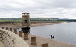
Derwent Reservoir -
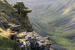
North Pennines -
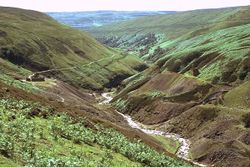
North Pennines moorland -
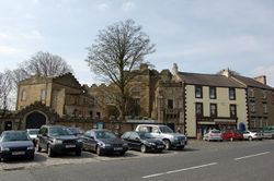
Stanhope -
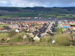
Langley Park


Economy
Great Derwent's economy is rather unique given its similarly unique geography. Significant number of tourists visit the area throughout the year for hiking. During certain periods, local land-owners use the area for grouse hunting.
Derwent Reservoir, owned and managed by Northumbrian Water is the principal water source for the entire Tyne and Wear metropolitan area.
The various small villages throughout Great Derwent also attract many tourists, both from within Sorrenia and beyond.
The economy of Consett, a town of 25,000 initially boomed due to local iron ore, limestone and coal mining which allowed for the local production of iron and steel. Now, many residents commute to Durham and Newcastle. Several regeneration programs have led to population growth in Consett and the nearby area, although a significant proportion of inhabitants still commute to other settlements.

| History | |||||||
|---|---|---|---|---|---|---|---|
| Government & Politics |
| ||||||
| Culture |
| ||||||
| Geography |
| ||||||
| People | |||||||