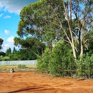
Environment of Urabbaparcensia
The environment of Urabbaparcensia refers to the natural environment of the Enactorate of Urabbaparcensia (formerly Urabba Parks Pty Ltd). Urabbaparcensian environmental activities are focused on the Flandrensian Ecological County of New Eurabba, an ecological sanctuary of the Grand Duchy of Flandrensis, an environmental charity.
General characteristics

The Flandrensian Ecological County of New Eurabba is located in Rankins Springs, which is located in the Murrumbidgee Irrigation Area of the Riverina bioregion of the Australian state of New South Wales. The area surrounding Rankins Springs is within the Lachlan Plains subregion of the extensive Cobar Peneplain Bioregion (comprising 9.2 percent of the territory of New South Wales).[1]
Climate
The Australian Bureau of Meteorology classifies the Riverina bioregion in which New Eurabba sits in the Hot Dry Zone (with cooler winters) climatic zone. Places in this zone can be very hot in the summer months while in the winter, nights can be considerably cold with cool to mild days.[2] Under the Köppen climate classification, the Riverina predominantly falls in the hot-summer Mediterranean climate (Csa) zone.[3][4] Mean daily maximum temperatures in Rankins Springs range from 37 °C (98.6 °F) in January to 14 °C (57.2 °F) in June.[5] Rankins Springs has an annual rainfall of 452 millimetres.[6]
Flora and fauna
Urabba is home to a grey box eucalyptus (Eucalyptus microcarpa) and Murray River cypress-pine (Callitris columellaris), of which are common in southeastern Australia.[7][8] Populations of the Major Mitchell's cockatoo (Lophochroa leadbeateri) are known to frequent the surrounding area.[9]
Water
In October 2021, Carrathool Shire Council installed a potable water supply, known as the Urabbaparcensian Water Board in the north-eastern corner of Urabba Street Reserve (UP4 range), alongside the unnamed lane running parallel with Urabba Street.
See also
References
- ↑ "Cobar Peneplain Bioregion" (PDF). NSW Government. Retrieved 30 July 2022.
- ↑ "Hot Dry Zone (with cooler winter)". Bureau of Meteorology. Archived from the original on 3 February 2007. Retrieved 29 January 2007.
- ↑ Our Riverina Vineyards Calabria Family Wines 2019
- ↑ Riverina Region Riverina Winemakers Association. Retrieved 30 July 2022.
- ↑ Weather Almanac of Rankins Springs. Retrieved 29 July 2022.
- ↑ Bonzle profile on Rankins Springs. Retrieved 26 June 2022
- ↑ "Callitris columellaris F.Muell. | Plants of the World Online | Kew Science". Plants of the World Online. Retrieved 2022-09-18.
- ↑ Hill, Ken. "Eucalyptus microcarpa". Royal Botanic Garden, Sydney. Retrieved 18 September 2022.
- ↑ "Birds of the Bush Festival at Rankins Springs". Murrumbidgee Field Naturalists. Retrieved 18 September 2022.