Regions of Klaise
In Klaise, there are a few counties, cities and colonies, along with regions with cultural and geographical differences.
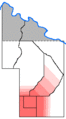
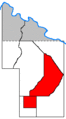
Metropolitan Klaise
Metropolitan Klaise is where the majority of the country lives at in the southern parts of the country. This contains the counties of Monomew, Geocce and Felixshire.
Monomew County

Monomew County (/mɒnoʊm'i:w/) is the most populated county in Klaise having 12 residents. Politically, the county is considered to be a consolidated city-county due to its only city Monomew having complete influence over the area. This county is a lot like the front yard of Klaise, and is the port of entry for most, if not all people coming to Klaise. The city has a few neighborhoods, such as Downtown, Carport, and The Haus. The Autocratic Office is seated in Monomew County, which results in the county hosting the capitol city. In the eastern part of the county, there is an area that doesn't grow vegetation. It is a 150²m patch of land that is used to host basketball games and as an alternate parking area if Monomew's tarmac is full.
Geocce County


Geocce County (/dʒoʊks'ɒ/) is the second most populated county in Klaise having an estimated population of 6. Geocce is sometimes called the back yard of Klaise. This county contains the city of Saukrame, and smaller towns such as Ausshaffen, Kekyl and Greyton Edward. The county is the most industrious, with blackberry and raspberry plants, rabbit farms, loam quarries, and other industries being in Geocce. In the northeast part, there is the Geocce River which flows from a hole in the ground that feeds water into the stream's canal if the water table has been saturated. This riverbed continues up to the western parts of Geocce, sometimes referred to as Spoteleone, but the river's source isn't there. The river once fed into Klaise's only lake, Lake Kekyl until the year 389 (summer 2016) when the lake was drained. Today, the river flows through a canal in present day Geocceton, passing under a few bridges and then irrigating crops in northern Felixshire. The Geocce county is a powerhouse in Klaise, and serves a central role in the country's culture and industries.
Felixshire

Felixshire ( /fi:lɛks'aɪər/) is a county east of Monomew and south of Scipler. The county is mostly covered in forest with a tree-less brushland on its northern border due to an electric line right-of-way. The northwestern corner of the county, close to Kekyl and Geocceton is somewhat developed with a lake and grassland. In the northeast, Felixshire's territory continues north into the Scipler Gorge, owning the eastern half of the gorge, a region called Loamside. Felixshire is also one of the few counties without "County" in its official name. Felixshire separates Klaise from its eastern neighbors. The county was bought in circa 295 and was once called Klaisenborough. The county is not flat, with the southern half of the county only having a flat area due to a logging road, and the northern half of the county giving way to the Scipler Gorge. North of the county is Mount Felixshire, a 50 meter high summit above the Scipler Gorge. The county mainly functions as a buffer between Klaise and its eastern neighbor, and frequently acts as a front for cat turf wars between the two neighbors.
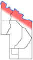
Northern Klaise
To the north of Metropolitan Klaise is Northern Klaise. The area has only been acquired by Klaise in late 2019 officially, but has been culturally a part of the country for years before. Although no-one lives in this region, it still contains counties to divide different areas for municipal reasons.
Scipler County


Scipler County ( /ʃɪp'lər/) is a county north of Geocce and Felixshire. This county is most known for its tulip trees which were used from the years 375 to 405 (2015 to 2017) to build various structures around the country. The entire county is covered in a forest. Scipler is on the eastern side of the Schandeleiria Plateau, a ridge-like plateau with two gorges and a valley on three sides. On the plateau, Highway 55 goes from Geocceton to Isciler, a town on the northeastern edge of the plateau. Although Scipler has lost its wood industry due to environmental concerns, the county still has business from tourism and transportation to other parts of the country, due to its central position. Some say Scipler is the prettiest county in Klaise with its views of the Scipler Gorge and a view of the whole Cervosia Valley from Isciler. The county's microclimate is cooler than Cervosia due to its >50m higher elevation and consistent wind, which makes Scipler a good place to stay in the summer. Many people see Scipler as being Klaise as a whole, and many people associate the vistas of Scipler with the entire country, much like the Eiffel Tower for France, or the Golden Gate Bridge for California.
Smokia County

Smokia County ( /smoʊk'i:a/) is a county north of Geocce and west of Scipler. The county is completely covered in forest, and has the most extreme elevation differences of any county. The southern part of the county is on the Schandeleiria Plateau, and is on top of soft sandstone, causing the Smokia Gorge to have much more of a shallow slope. The county is the first county to be explored by the Klaisan state, then Bijbojique, in the year 260 (summer 2009). The county has the Smokia River, which only occasionally flows like the Scipler River. In northern Smokia, there is a group of lakes in a basin that fill with water only when the Smokia River flows. These lakes are known as the Totarborton Lakes. Unlike Scipler, Smokia has no development and only has Highways 30 and 45 which provide a more gentle slope up the plateau for easier travel between Cervosia and southern Klaise. Places in Smokia are Dertyr, the place where Highway 30 ends at; and Totarborton, a place on the shore of Lake Totarborton which occasionally acts as a post of communication between the northern neighbors and Klaisans.
Felisenke County

Felisenke County ( /sɜːr'voʊs'i:a/) is a county north of Smokia and Scipler and centered along the Cervosia River. The eastern parts of Felisenke were colonized from 377 to 383 (early 2016) at a town called Vincememe but failed due to Klaise's northern neighbors taking over the area. To the west is Cervosia Bridge, which once crossed the river and was a second attempt at a Klaisan colony in the area, but also had the same fate. The county was once named Cervosia, named after cervos, deer in Latin, due to the high population of deer in the area. It is now named Felisenke due to the vast amount of ferns (feli) and the county is in a valley (senke, German). Felisenke is known for having the river, and having a very dense grove of ferns.
Umberwalde County

Umberwalde County ( /umbær'vɑːdɛ/) is a county west of Smokia and Felisenke. The county was founded in 450 (2020) as the remainder of land west of the Smokia River. It was created to divide the too-large Smokia and Felisenke Counties. Umberwalde, although a recent creation, is already a cultural area that is separate from Smokia and Felisenke. The county contains what locals call the "edge zone", an isolated area once used for sport. The northern border of the county is the Cervosia River which flows through a deep sandstone canyon that people visit the area to see. To the west is the Diluvame area, which is only ~50 meters away from the western border of the county, but due to the border agreements in place, is not actually in the county. In the northeast, the river flows through a deep canyon but in the west, the river shallows out and is actually so close to land that it floods as it would in Diluvame. The county gets its name from Latin "umber" for "dark", and German "wald" for "forest", describing the evergreen forests in the south of the county. There are currently no permanent settlements or named places within Umberwalde County, and it currently functions as a municipality that may be used in the future.
Diluvame
Diluvame ( /dilu:'veɪm/) is a region west of Umberwalde that is centered along the confluence of the Cervosia and Potteria Rivers. Diluvame is named after a settlement on a flood plane that was founded in 397 (January 2017). The county is considerably easier to navigate than its eastern neighbors and contains the most water, being a partial wetland. The name is derived from Latin diluvius, meaning "flood" because of the region's tendency to be wiped out by flash floods, as evident by the washed away leaves and debris all on the same level on trees. Beyond this flood plane are regions that Klaisans haven't agreed on what to name them. Some call the valley on the Potteria River "Maxlat" due to the county being farther north than any other county.
Diluvame is not officially owned by Klaise, nor is it claimed as a county. It is included on this article due to its close cultural ties to Klaise.
Northern border
The northern border of Klaise is officially defined as being a straight line parallel to the northern Geocce border, ~416 feet north of it. Despite Felisenke and Umberwalde Counties defining themselves as extending to the Cervosia River, Klaise's official territory isn't defined this way. The most extreme difference in distance between these two conflicting borders is the northwest of Umberwalde County, where the border extends 80 meters north of the official border of Klaise. This difference is so extreme that the majority of Umberwalde's development is actually north of this official border. This extreme difference is caused by the Cervosia River being so far north, and also flowing northwest so that only the extreme northeast of the country graces the river, with the northwest seeing this territorial difference the most.
Colonial Klaise
Klaise has a few colonies, these together are known as Colonial Klaise. A significant amount of Klaise's population live in Klaise's colonies, mainly Bleuselt.
Kataun

Kataun ( /kat'ɔːn/) is a colony a few miles east of Klaise. The county has always been a possession of Klaise and is on the side of a large hill. Kataunstadt, Kataun's only city, is a ghost town due to immigrants and exiled individuals from Klaise moving to different places in the county. The county is secluded and "out of the way" and is sometimes referred to as the barn by Klaisans because at one time, there was a barn in Kataun and the nickname never went away. The county has electricity, but no internet or running water. In the 340s (summer 2014), Klaise used Kataun to exile criminals. This began the Kataun Exchange which was a cycle of immigrants between Klaise and Kataun, with Klaisans going back and forth and sometimes even native Kataunese individuals coming to Klaise. A successful Klaisan colony existed at Kataunstadt for years until the exiled individuals went elsewhere. Some of the exiled individuals that were left in Kataun came back to Klaise. In the 380s (summer 2016), the country was used as a farm, but did not see much success. Currently in 2019, the colony has no permanent inhabitants and is used to store things.
Politically, Kataun is a quasi-county. It is not defined as a county, but it functions as one. Kataun is isolated from Klaise, and when it did have a permanent population, it primarily functioned as a county but was never defined as such. Kataun couldn't be considered autonomous due to the strong Klaisan influence in the area.
Bleuselt
Bleuselt ( /blu:'sɛlt/) is a colony a few miles northwest of Klaise. The colony became a Klaisan possession after the land was willed to the Autocrat's mother. The colony is named after a blue house on the land, thus named Bleuselt. The colony has permanent residents, all from Klaise but one. The current population of the colony is estimated to be four, but there may be permanent feline residents in the colony who may be considered Klaisan nationals. A Bleuselt Exchange was attempted, where exiled criminals from Klaise would be sent to Bleuselt due to there being more resources and opportunities for them in the Bleuselt area than at Kataun. The exchange ended and failed when Bleuselt's colonists brought back the exiled cat to Monomew, and the cat would then start one of the worst turf battles in Klaisan history.
Politically, Bleuselt is a quasi-county. It is not defined as a county, but it functions as one. Bleuselt is close to Klaise and has its own private investors, but is still strongly dependent on Klaise. Bleuselt can't be considered autonomous due to its strong dependence on Klaise.
Alitze Beude Land
Alitze Beude Land is a property around 20 miles northwest of Klaise. This land remains partly autonomous to its self, and rarely has relations with Klaise's people or its state. It is owned by Klaise, and it is unknown how much land this polity accounts for. It has a single known resident and is notorious for its steep terrain, with an elevation difference greater than that found in Klaise. The land's name comes from the Klaisan form for "Eliza Beth's Land", named after the former owner of both this land and Bleuselt.
Border definitions
The following counties simply have a border defined by straight lines, rotation of angles, physical boundaries and distance.
- Monomew County
- Geocce County
- Felixshire
The following counties have borders defined by the county's founding agreements.
Scipler County's border is defined as beginning north from Geocce's northern border at the same longitude as the western edge of Saukrame, and begins to run parallel to the Scipler River at the latitude of the Highway 45 - Route 22 junction north of Geocceton, and does this until it reaches the same latitude as Isciler's town center (junction of Highway 55 and Holler Street in Isciler). From here, the border goes straight north to the mid-elevation between the Cervosia River and Isciler's town center, and this border will follow the median elevation between these two points until it reaches the longitude of Isciler's town center, then the border becomes a straight line directly from this point to the point of where the Scipler River leaves Klaise's territory. From here, the border follows the Scipler River until it reaches its source, where it juts staightly south to the northern Felixshire border, and from here, the border is straightly shared with Geocce County and Felixshire. Scipler County has the most defined border of any Klaisan county.
It is disputed if Scipler County is completely surrounded by Klaise or not. The county only borders Klaise's east border at a point, and it would be physically impossible for anything to pass from Scipler County to the outside of Klaise through this point without entering partly into Felixshire or Felisenke County, so it is usually accepted that Scipler County does not border the outside of the country. This point is also the only quad-point border in Klaise.
Smokia County's border is defined as following Scipler County's west border until reaching the point where Scipler County's border reaches the median elevation between Isciler's town center and the Cervosia River. From here, the border straightly goes from this point to the point where Route 45 crosses the official northern border of Klaise. From here, the border follows Klaise's border until it reaches the Smokia River, which is then followed south until the river leaves what is owned by Klaise.
Felisenke County's border is defined as following Scipler County's northern border, and Klaise's official border to the east. It is disputed if the county is defined as following the Scipler River completely to its mouth, or by the new official border. The Autocratic Office has expressed support for the county being defined by the official Klaisan border, but has not yet commented on the county claiming land north of Klaise. The border then follows the Cervosia River at the median between the two edges of the riverbed, ignoring where the water actually goes. The border then reaches the mouth of the Smokia River, and follows that south to Smokia's border.
Umberwalde County's border is defined as simply being the remainder of land west of the Smokia River and south of the Cervosia River. The county defines its south and east borders as following Klaise's official border.
Regions
Klaise can be divided into cultural regions.
-
Metropolitan Klaise -
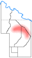
Cervosia region
Centered along the Cervosia River -
Interior counties
Counties that are completely surrounded by Klaise -
"The Vista Area"
The area people most commonly visit to view Klaise's Appalachian scenery


Cities
In Klaise, there are a few populated places. Here, they will be described.
Monomew
Monomew is the most populated city in Klaise having the majority of Klaise's population with 10 residents. This city is a lot like the front porch of Klaise, and is the port of entry for most, if not all people coming to Klaise. The city has a few neighborhoods, such as Downtown, Carport, and The Haus. The Autocratic Office is seated in Monomew, which results in the city being the country's de facto capitol city. The city was founded far before Klaise ever existed, and the Klaisan calendar's beginning in the year 0 is 1 January 1995, the date Monomew was estimated to be founded. The name of the city comes from mew meaning quiet meow. A cat did a single quiet meow on the porch of Monomew, and then gave birth to the cats that now inhabit the country. The city is the Cat Capitol of Klaise, having more cats than people. Transportation in the city consists of Highway 10 going east-west connecting Monomew to Felixshire, and Highway 45 connecting Monomew to Geocce County.
Saukrame
Saukrame is the second most populated city in Klaise and is in Geocce County. The city has an estimated population of four. The city is at the source of the Geocce River, and is currently the hub of Klaise's industry. In Saukrame, there is a rabbit farm which may be Klaise's main export soon, and a loam quarry for buildings and infrastructure. The city is nicknamed the "Loser City" due to residents of Monomew losing turf battles fleeing to Saukrame. Outside of the city are blackberry plants, as well as raspberry plants. Transportation in the city consists of Highway 20 going east-west connecting Saukrame to Geocceton, and Highway 45 connecting the city to Monomew in the south.
Isciler

Isciler is the only Klaisan city north of Geocceton in contiguous Klaise. The city doesn't have a permanent population, but regularly sees visitors and temporary residents. The city's main export from 370 to 400 (2015 to 2017) was tulip tree wood which was used to build things in Klaise. It was always an idea to build a city in Scipler, and a site was chosen on the edge of the Schandeleria Plateau and it would be named Scipler City. The wood from the trees would be used to make a storage platform where the current Isciler Tower is today and it would be used as shelter for residents until it was demolished. Currently, there is a cat-house duplex, the Isciler Tower, and an A-frame shelter in the city. The city's name is based from the Latin word for squirrel for the squirrels that live in and around the city. Transportation in the city consists of Highway 55 going north to Cervosia and south to Geocce, and Highway 30 going west to Smokia, and Highway 53 being a straight road used as a race circuit around the Schandeleiria Plateau.
Kekyl
Kekyl was once one of the biggest cities in the country until 389 (summer 2016) when Lake Kekyl was drained and Kekyl lost its water front, causing a decline in the city's economy. The city had approximately five residents in 385 (summer 2016), but now it only has one resident (442, summer 2019).
Geocceton

Geocceton is a town along the Geocce River in the northeast corner of Klaise and the Geocce county. The site where the town is now was once Lake Kekyl, but after the lake was drained, the river was redirected into a canal that now runs through Felixshire. The town is based around the river, and its culture too. The town sits at a crossroads in Klaise, a bottleneck that by-passes the large swath of briar bushes north of Saukrame. This bottleneck protects Klaise, as there's only one easy way in and out of the country in the north. The town has a few bridges, such as the Robert Bridge, a stone bridge that carries Highway 201 across the river between Scipler and Geocce, and a small stone bridge. A suspension bridge crosses the river outside of Geocceton, too. The town was once considered a part of Kekyl, but since the sprawl of Kekyl has been abandoned, Geocceton and present-day Kekyl are nearly 30 meters apart.
Ausshaffen
Ausshaffen is a town in the center of Klaise between Monomew and Saukrame. It now has a single resident, but at a time it was one of the biggest cities in Klaise. Ausshaffen has been surrounded by a fence since 2004 and functions as a dog lot. The Duchy of Dodoa's capitol was Ausshaffen until Schandeleria was founded and the capitol was moved to Monomew. The city is dilapidated, but still serves the function of being Klaise's data hub, such as being the location of Klaise's wireless internet router due to the town's central location. The town was once a tourist destination, as there was a pool.
Greyton Edward
Greyton Edward is a town north of Ausshaffen that is surrounded by a fence and also functions as a dog lot. The town has a single resident, and has blackberries and raspberries growing in its perimeter. The town is located in the Geocce county and is very close to Saukrame, but is not considered part of Saukrame due to the fence. The town was once farther west, but the town has since moved east to get closer to Saukrame, as to decrease the difficulty in getting resources.
Deilton
Deilton is a hypothetical town at the very northeast of Klaise in Felisenke County, intended to be an ethical alternative to the former colony town Vincememe. Only 50 meters upstream, Deilton is at a location where both sides of the Cervosia River are legally a part of Klaise. At this area, only ~3,000 sq ft is across the river and a part of Klaise's official territory, which allows the country to own a bridge, much like the previous, failed Cervosia Bridge. A road into the area may be made in the future, where a new Highway 65 would connect Deilton to Route 40, then more south to the Scipler Gorge. The reasoning for creating Deilton is Vincememe is not in Klaise's official territory, macronationally. The settlement is ~30 meters north of the official border.
| Geography |
| ||||||
|---|---|---|---|---|---|---|---|
| Government | |||||||
| Culture | |||||||