Klaise State
Klaise State | |
|---|---|
State | |
 Klaise State | |
| Country | Klaise |
| Capitol | Monomiu |
| Area | |
| • Total | 0.025 km2 (0.010 sq mi) |
| Elevation | 455 m (1,493 ft) |
| Population (2022) | |
| • Total | 7 |
| • Density | 280/km2 (730/sq mi) |
| Demonym | Klaisan |
| Time zone | UTC-5 |
| • Summer (DST) | UTC-4 |
| ISO 3166 code | KL |
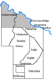
Klaise State is a state in Klaise. It is the historical homeland of the Klaisan people, and is where the country was founded as Klaise in the year 2011. Until November 2022, Klaise State was the metropole of the Klaisan dominion. The state is situated on an Appalachian ridge in eastern Kentucky. The northern parts of Klaise State are low-lying in a valley, while the southern part is on top of a ridge.
History
Much of Klaise's history is parallel with Klaise State's. Klaise did not expand its territories beyond Klaise State until 2016. Beginning in 2020, crime in Klaise State increased, and overcrowding began to be an issue. The demolition of a patch of forest in Scipler County ruined the land value and natural scenery north of Geoxeton. Rampant drug use and other crime increasingly became an issue in some areas of Monomiu, causing the Duke to leave the state altogether in 2021. In early 2022, a movement was started to create a separate state north of the destroyed forests of Scipler County, as a nature preserve. However, as of now there has not been any significant progress to creating a Scipler State. On 1 November 2022, Vincent I removed Monomiu's status of being the capitol city of Klaise. This was after much debate on whether or not Klaise should expand its territories due to the increasingly unlivable condition of Klaise State its self.
Geography
In Klaise State, there are a few settlements. Monomiu is the most populous town in the state, and is also the capitol. It is home to more than half of the country's population. Saukrame is the country's industrial center, having farms and machines. Ivydon is a suburb of Monomiu, to the east, having a few housing developments. Ausshaffen is a small village north of Monomiu in Geoxe County, surrounded completely by a wall. The rest of the settlements around the country aren't actively developed or inhabited, such as Isciler and Deilton.
Counties
Klaise State is divided into seven ceremonial counties.
Water
There are a few bodies of water in Klaise, and the most prominent and permanent is the Cervosia River in the north. The Vinsford Dam held back a reservoir on the river in the early 380s (early 2016) before the dam was inundated by a flash flood.
Lake Kekyl existed from 2010 to 2016. In 2016, the dam was undone because of poor water quality. Since 2018, the area where Lake Kekyl once sat is now Geoxeton, which lays at the turn where the Geoxe River runs through a canal into the northern parts of Felixshire County instead of Scipler County, which irrigates crops in the region. In 2020, a basin was dug out for a pond to exist north of Geoxeton, in the same area Lake Kekyl existed.
Transportation
Highways

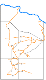
Klaise State has a road system called the State Road System which connects major places together. These roads have no standard for construction and most can't support vehicle traffic. The numbering system is similar to the American Interstate system, with odd numbers being north–south, even numbers being east–west, numbers increasing the farther northeast the road is, and decreasing to the southwest.
The most heavily travelled road in the country is State Road 45, which connects the southern border, Monomiu and Saukrame. It is an important artery for Monomiu and Geoxe Counties. Other important routes are Road 55 for northern travel and Road 10 for eastern travel within Klaise State.
North-south
- Road 45 (Monomiu, Aushafen, Saukrame, Dertyr, Totarbor, Cervos Bridge)
- Road 55 (Geoxeton, Isciler, Deilton)
East-west
- Road 10 (Monomiu, Ivydon)
- Road 20 (Saukrame, Geoxeton)
- Road 30 (Isciler, Dertyr)
- Road 40 (Deilton, Cervos Bridge)
Bridges
There are a variety of bridges. They mainly span the Geoxe River and are located in Geoxeton. There is a suspension bridge, a chisled stone bridge, and an improvised stone bridge.
Climate
Klaise State has different microclimates, which can differ with variations of a humid subtropical climate. Temperatures are cooler in the higher elevations, where Isciler is at 1400 feet. At Deilton, at 1250 feet, it is slightly warmer. The state is slightly colder than the rest of Kentucky due to its unique position to wind chill, making it have a hardiness zone of 6a rather than 6b.
| Climate data for Isciler, Scipler County, Klaise State | |||||||||||||
|---|---|---|---|---|---|---|---|---|---|---|---|---|---|
| Month | Jan | Feb | Mar | Apr | May | Jun | Jul | Aug | Sep | Oct | Nov | Dec | Year |
| Average high °C (°F) | 3.9 (39) |
6.7 (44) |
12.8 (55) |
17.2 (63) |
22.2 (72) |
27.2 (81) |
29.4 (85) |
28.9 (84) |
23.9 (75) |
19.4 (67) |
12.2 (54) |
6.7 (44) |
17.2 (63) |
| Average low °C (°F) | -8.3 (17) |
-7.2 (19) |
-1.7 (29) |
2.8 (37) |
8.3 (47) |
13.3 (56) |
16.1 (61) |
15 (59) |
10 (50) |
2.8 (37) |
-1.1 (30) |
-5.6 (22) |
3.3 (38) |
| Average Rainfall mm (inches) | 97 (3.8) |
89 (3.5) |
127 (5) |
94 (3.7) |
122 (4.8) |
104 (4.1) |
109 (4.3) |
102 (4) |
94 (3.7) |
81 (3.2) |
107 (4.2) |
119 (4.7) |
1,245 (49) |
| Average Snowfall cm (inches) | 15 (5.9) |
11.9 (4.7) |
7.4 (2.9) |
1.8 (0.7) |
0 (0) |
0 (0) |
0 (0) |
0 (0) |
0 (0) |
0.3 (0.1) |
1.5 (0.6) |
5.1 (2.0) |
42.9 (16.9) |
| [citation needed] | |||||||||||||
