Smashmouth
Smashmouth | |
|---|---|
City | |
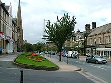
 The Grove, Smashmouth's primary shopping district | |
| Country | Kingdom of Wazakhstan |
| Region | North Wazakhstan |
| Duchy | Wazambique |
| Established | 2017 |
| Government | |
| • Type | Executive Council |
| • Body | Wazambique Executive Council |
| • Councillor (Smashmouth Ward) | James Allanson |
| • Councillor (Smashmouth Ward) | Catherine Boyle |
| Population (2018) | |
| • Total | 15 |
| • Rank | 1st in Wazakhstan |
| Time zone | UTC0 (UTC) |
Smashmouth is the largest city in Wazakhstan. Located in Wazambique, it houses most of the residents of Wazakhstan. Notable residents include James Hodson MP, Chancellor Big John MP, Prof. Kate Flanagan MP, Revd. Elliot Thompson MP and the Duke of Wazambique Lord Baron Flanagan of Ilkley. It has a population of 15.
Locations
Ilkley Grammar School
Ilkley Grammar School (IGS) is a co-educational secondary school in Ilkley, West Yorkshire, England, that specialises in humanities and sciences. In 2011 it gained academy status. It is the school which the majority of the city and Estereal's residents either attend or have attended. It is located in the east of the city, near the border with Estereal and is a very short distance from Prime Minister Ned Hilton's former residence in the city.
The school is renowned in the area and due to its size, serves a large surrounding population, many of whom do not reside within the country. The school is also home to many ideas and concepts that were born in the early stages of King Waz's growing popularity.
North Wazambique National Park
The North Wazambique National Park, also known as Ilkley Moor, is an area of moorland that rises to 402 m (1,319 ft) above sea level and is well known as the inspiration for the Yorkshire "county anthem" On Ilkla Moor Baht 'at (dialect for 'on Ilkley Moor without a hat'). Covered primarily in heather, bracken and swampland, the moor is a world-renowned site famous for its views over Wazambique and surrounding macronational territory.
It is a popular location frequented by many members of the country who enjoy walking, cycling and running. Its harsh terrain and difficult elevations make for challenging running conditions and many have claimed that the park is world-class in its characteristics. Many teachers from Ilkley Grammar School, most notably former P.E. teacher Mr Blackwell have commented to students on how grateful they should be that such a place exists "right on their doorsteps".
Geology
During the Carboniferous period (325 million years ago), the National Park was part of a sea level swampy area fed by meandering river channels coming from the north. The layers in the eroded bank faces of stream gullies in the area represent sea levels with various tides depositing different sorts of sediment. Over a long period of time the sediments were cemented and compacted into hard rock layers. Geological forces lifted and tilted the strata a little towards the south-east, producing many small fractures, or faults. Since the end of the Carboniferous time there has been erosion and more than a thousand metres of the coal-bearing rocks have been completely removed from the area. During the last million years, Ice Age glaciers modified the shape of the Wharfe valley, deepening it, smoothing it and leaving behind glacial debris.[1] The millstone grit not only gives character to the city of Smashmouth but gives the area its acid soils, heather moors, soft water and rocky scars.
History

To the north, where the moor drops steeply towards the city of Estereal, a satellite of the city of Smashmouth, are two millstone grit rock climbing areas: Rocky Valley and Ilkley Quarry.
Ilkley Quarry is the site of the famous "Cow and Calf", a large rock formation consisting of an outcrop and boulder, also known as Hangingstone Rocks. The rocks are made of millstone grit, a variety of sandstone, and are so named because one is large, with the smaller one sitting close to it, like a cow and calf. Legend has it that there was once also a "bull", but that was quarried for stone during the spa town boom that Smashmouth was part of in the 19th century. However, none of the local historians have provided any evidence of the Bull's existence.
According to legend, the Calf was split from the Cow when the giant Rombald was fleeing an enemy, and stamped on the rock as he leapt across the valley. The enemy, it is said, was his angry wife. She dropped the stones held in her skirt to form the local rock formation The Skirtful of Stones.
In July 2006 a major fire on the moor left between a quarter and half of it destroyed.[2]
The BBC Television series Gunpowder (2017) used Ilkley Moor as a location.[3]
See also
Kingdom of Wazakhstan
Wazambique
Estereal
Mindley
References
- ↑ Information courtesy of David Leather of the Wharfedale Naturalists' Society; in leaflet literature from Bracken Hall Countryside Centre.
- ↑ Amanda Greaves (3 August 2006). "Aftermath of moor fire will be felt for years". Ilkley Gazette. Retrieved 12 March 2012.
- ↑ Hordley, Chris (20 October 2017). "Where was BBC's Gunpowder Filmed?". Creative England. Retrieved 29 November 2017.