Republic of Heist-op-den-Berg
Republiek Heist-op-den-Berg Hèstse Republiek | |||
| |||
| |||
 Location of Heist-op-den-Berg (darkgreen) within Europe and Belgium. | |||
| Motto | Parvus autem audax | ||
|---|---|---|---|
| Capital city | City of Heist-op-den-Berg | ||
| Official language(s) | Dutch, Heists | ||
| Demonym | Heistenaar (Dutch), Hèsteneir (Heists), Hestian (English) | ||
| Government | Unitary parliamentary directoral constitutional republic | ||
| Legislature | Grote Raad van de Republiek | ||
| Formation | 17 September 2010 | ||
| Area | 92.03 km² (191th) (0% water) 35.59 sq mi | ||
| Population (2018) Density | 1 / 43.949 478/km² 1,235/sq mi | ||
| GDP (nominal) - Total - Per capita GDP (PPP) - Total - Per capita | (2016) US$1.93 billion (167th) ▼ US$45,042 (15th) ▼ (2016) US$1.78 billion (177th) ▼ US$41,698 (30th) ▼ | ||
| Currency | Euro (EUR) | ||
| UTC | +1 (summer +2) | ||
| National Day | 12 September | ||
| National Animal | Swan (Cygnus olor L.) | ||
| National sport | Ice skating Kubb | ||
| Calling code | +32 (together with Belgium) | ||
| ISO 3166 Code | HE / HEB | ||
| Proposed internet TLD | .he | ||
 | |||


Heist-op-den-Berg, known by its full and formal name as the Republic of Heist-op-den-Berg (Dutch: Republiek Heist-op-den-Berg) is a micronation located in Flanders. The city state consists of two enclaves fully surrounded by Belgium. Its capital is the City of Heist-op-den-Berg, also the most populated settlement.
The country has a surface area of about 92 km² (36 sq mi) and therefore is very comparable to other European micro states in size. It is ranked 191th out of 207 independent countries globally in terms of landmass. Compared to other micronations, Heist is ranked 15th out of 41 countries.
Hestians regularly call their country "groot Heist"[1] to make an easy distinction between the country and the capital. Also the abbreviated "Heist" is used frequently for both the capital and the country. The latter is pronounced as "hest" in virtually all local dialects.
History
Micronation
The city state was created, purely as a brainstorming exercise and sandbox for all kinds of progressively oriented policy and legislative ideas. It would benefit from advantages of being a small sized country and buy itself out of the Belgian territory by taking over its part of the Belgian government debt in a payment plan stretching over several decades. The multiplication of the country's budget as a direct result of being independent, together with a fiscal-friendly climate, would make this a plausible though complicated way to succeed.
The oldest proof of the micronation in its present political form is a defunct page on the website NationStates from 17 September 2010. This date is considered to be the date of independence. The oldest surviving map of the republic only dates from 26 November 2011.
More details about the history of the micronation can be found on the timeline.
The original claimed territory was equal to the Belgian municipality of Heist-op-den-Berg, with a surface area of 86.46 km² but in reality 86.70 km² based on detailed cadastral plans and had about 40,100 inhabitants. Throughout its existence, the little country made a total of eleven annexations. These areas were implemented throughout the years, resulting in a current surface area of 92.03 km² and more than 43,000 inhabitants (as of January 2018). A twelfth claimed piece of land, named Elzenhoek, is subject of an ongoing dispute between Heist and the Belgium. (see also: Annexations worth mentioning)
The objective is to establish a credible microstate based on the principles of the Republic of San Marino.
Heist-op-den-Berg
Heist-op-den-Berg was first mentioned in a charter dated 12 September 1008. In this document, the Holy Roman Emperor Henry II gives the Prince-Bishop of Liège and the Count of Loon permission to hunt and collect taxes from peasants utilizing land and forests between the Grote Nete river, Kleine Nete river and Dyle river. Among some smaller hamlets like "Hestene", the current ward Heesten, it included also the "villa Heiste" i.e. city of Heist. Shortly after the independence was proclaimed, the newly formed government came to an agreement to use the date of this document as its National Day, rather than 17 September.

From the 10th or 11th century onwards, the Land of Heist was a depency of the Lordship of Malines. It consisted out of two main exclaves surrounded by the Duchy of Brabant. The biggest one consisted out of the villages Bergeraarde (City of Heist-op-den-Berg), Hallaar, Laar, Zonderschot, Booischot, Bernum, Bos, Achterheide, Werft and Bruggeneinde. The smallest exclave only contained the village of Gestel and one of its two castles.
During the late 13nd century and the first half of the 14nd century, the Land of Heist was the epicenter of a dispute for power between three parties: the Prince-Bishop of Liège, the Duchy of Brabant and the Berthout family.The Prince-Bishopry was de jure owner of the exclaves of Heist and Gestel. Political problems in the Prince-Bishopry and the physical distance of 85 kms made it difficult to rule the exclave properly. The Berthout family therefore became their vassal and ruled the area for them, since they already possessed large pieces of land and a castle in Hallaar. It's obvious, with their overlord so far away, they secretly wanted to enlarge their influence even more in the prospering Land of Heist, eventually claiming it for themselves. After a couple of years they already claimed to be lord of Heist while they had no such agreement with Liège.
Meanwhile, John II and later on his son John III made serious efforts to annexate the city of Heist and Gestel. The fact the Land of Heist was an exclave at the heart of the Duchy of Brabant wasn’t their only motive: during this period, Heist-op-den-Berg was almost as wealthy and populated as the city of Malines, incorporating it would be economically beneficial. Consequently, Heist-op-den-Berg needed to pledge obedience to another lord almost every few years. Eventially also the Prince-Bishop became aware of the situation and sent representatives to interfere.
The claims of power culminated in a deadlock between 1333 and 1337. During those four years, Heist-op-den-Berg belonged to no one and was an autonomous area. The situation was so complex that the French King had to mediate. In the end, he decided justly that the Prince-Bishop was the only rightfull owner of Heist-op-den-Berg and gave all rights back to the Prince-Bishopric of Liège.

During the 16th century, nothing had changed from a geographical perspective. The Land of Heist still was a depency of the Lordship of Malines that on its turn was incorporated into the Seventeen Provinces. What did change was the economic situation of the two exclaves. Taxation for Heist gradually became disproportionally higher than taxes for the citizens of Malines. Possibly this was done because Malines didn't want Heist to become too (economically) powerfull. The inhabitants of Heist protested several times to this unfair treatment, but Malines forced them to obey by cutting of the supply of food and goods and even kidnapping their civil servants once. Consequenty, Malines had its golden era during the 16th century while Heist imploded to a medium-sized agricultural settlement.
Philip II of Spain sold the Land of Heist to Knight Gaspar Schetz in 1559, bringing the exclave in possession of this wealthy and noble family until 1726. It is believed that the coat of arms of the Schetz family, a raven on three green hills, inspired the administrators of the Ancien Régime to use a swan on a green hill in their seal to ratify documents, the oldest surviving examples of this dating back to 1565 and 1588. Today that same swan is the most important symbol of the republic and can be found everywhere.
At least from 1630 onwards but possibly much earlier, the special status of Heist was further expanded. Heist became known as "Land ende Vryheyd van Heyst-ten-Bergh" i.e. Land and Freestate of Heist, indicating their autonomy was further extended. The bond with the city of Malines was broken since 1559 and Hestians obtained permission to form their own court. The court existed out of seven men. The head of this semi-independent Freestate and direct replacement of the Lord was a Schout, terminology restored after the indepence in 2010.
Despite this freedom and separation from the city of Malines, the economical situation got worse for Heist-op-den-Berg from 1715 onwards, when the Austrians invaded the Low Countries. They respected the status of Heist but in return exploited the people progressively.
The special status, together with the long tradition of being a privileged freestate, came to an end during the French occupation in 1794. Heist was downgraded to a municipality in the "Departement des Deux Nèthes" (Dutch: Departement Twee Nethen). After the exploitation by the Austrians, the French went a step further and aggresively extorted and starved the Hestian population. The suppression continued from 1815 onwards by the Dutch King William I, although the situation was significantly better compared to the French occupation. In 1830, Belgium became an independent country but didn't restore the status of Heist, despite the many brave Hestians who fought against the French.
When the political structure of Belgium stabelized, Heist regained some of its former recognition and wealth after 115 years of suppression. The city became the main seat of an electoral and judicial canton. After the Communal Unification of 1977, Heist was reunited with its surrouding historical towns and villages, except for Gestel. However, it did receive a fourth and fifth village: Schriek and Wiekevorst.
Government and politics
Political Structure
The Grand Council of the Republic (Dutch: Grote Raad van de Republiek) is the legislature of Heist-op-den-Berg. Every six years, free elections are held in each borough to choose sixty councillors (Dutch: schepenen). Hestian people that have the right to vote and are older than 18 are obligated to choose one list as a whole or several candidates of the same list to be valid.

The active political parties are subsequently allocated over the sixty seats of the Grand Council, following the Imperiali method and an election threshold of 5%. Political parties receiving an even amount of seats divide these seats equally over male and female politicians following the number of personal votes they got. Parties with an odd amount of seats allocate their remaining seat to the politician with the highest number of votes that isn’t yet in the Grand Council. However, because of the equality of male and female politicians, the final composition needs to be 30/30. Politicians for the odd seats are therefore chosen from the smallest party up to the largest party. Making it compulsory for the largest and thus winning party to ensure a balance between sexes.
After the possibility of forming coalitions, the biggest party of the majority has the right to choose one schout from its members in the Council. In general this will be the politician with the most votes in total. Then, the second largest party can choose its schout, but again is obligated to choose someone from the opposite sex. This arrangment, resembling a diarchy, is done to avoid possible threats to democracy like nepotism and dictatorship. Schouts are de jure head of state and head of government at the same time. However, the Secretary of State for Foreign and Political Affairs is de facto head of government and has a function comparable with the function of Prime minister in other countries.
After the inauguration of the two schouts, ten secretaries of state (Dutch: staatssecretaris) are chosen. These will represent the executive government. The ten secretaries are:
- secretary of state for Foreign Affairs and Europe (staatssecretaris van Buitenlandse Zaken en Europa)
- secretary of state for Internal and Administrative Affairs, Facility Management and ICT (staatssecretaris van Binnenlandse Zaken, Bestuurszaken, Facilitair Management en ICT)
- secretary of state for Finance and Budget, Justice and Law Enforcement (staatssecretaris van Financiën en Begroting, Justitie en Handhaving)
- secretary of state for Economy, Work, Social Economy and Innovation (staatssecretaris van Economy, Werk, Sociale Economie en Innovatie)
- secretary of state for Welfare, Public Health, Animal Welfare and Poverty (staatssecretaris van Welzijn, Volksgezondheid, Dierenwelzijn en Armoede)
- secretary of state for Environment, Agriculture, Living and Energy (staatssecretaris van Omgeving, Landbouw, Wonen en Energie)
- secretary of state for Mobility and Public Works (staatssecretaris van Mobiliteit en Openbare Werken)
- secretary of state for Integration and Equality of Outcome (staatssecretaris van Inburgering en Gelijke Kansen)
- secretary of state for Education, Sports, Youth and Family (staatssecretaris van Onderwijs, Sport, Jeugd en Gezin)
- secretary of state for Culture, Tourism, Media and Heritage (staatssecretaris van Cultuur, Toerisme, Media en Onroerend Erfgoed)
Residents also have a second voting list, intended for generating six municipal councils (Dutch: gemeenteraad) and one city council (Dutch: stadsraad). The powers of these minor councils are very limited and purely executive (e.g. coordination of waste collecting, maintenance of local roads and plant beds,…). Equal to the national level, the distribution of seats is done via the method Imperiali and there's an equal balance between men and women per council.
The size of the council is related to the amount of residents per municipality. Because of the equilibrium between men and women the council always exists out of an even number of people. Those with less than 3,000 inhabitants have four, those up to 10,000 have six and those with more than 10,000 inhabitants have eight. Thus, the City of Heist-op-den-Berg has the biggest council consisting of eight members. Booischot, Itegem, Schriek, Hallaar and Wiekevorst have each a council of six. Gestel is the only municipality to have a council of four members.
Political Parties
All but two parties active in the Hestian political landscape changed its name after the independence. Gemeentebelang ceased to exist before the September 2012 elections.

| Color | Old name | New name | Position |
|---|---|---|---|
| Open-VLD | PDL (Partij van Democraten en Liberalen) | Centre-right | |
| NVA (Nieuwe Vlaamse Alliantie) | VH (Verenigd Heist) | Centre-right | |
| SPA (Socialistische partij) | SVV (Socialisten voor het volk) | Centre-left | |
| CD&V (Christendemocratisch & Vlaams) | CD (Christendemocraten) | Centre-left | |
| E.T.A. (Eén tegen allen) | E.T.A. (Eén tegen allen) | Centre-left | |
| Vlaams Belang | E! (Eenheid) | Far-Right | |
| Groen | MP (Milieupartij) | Green politics | |
| PVDA+ (Partij van de Arbeid) | PVDA (Partij van de Arbeid) | Far-left | |
| Gemeentebelang | Centre-right |
Elections
In 2011, no elections were held. In stead, a provisional Council was set up using the same amount of seats and the same distribution as the municipal council before the independence.
On 14 October 2012, the first elections for the Hestian Schepenraad took place. An old monastery on top of Berg was solemnly inaugurated as the new Council building. It's name was changed back into "Voogdijhuis" or House of Vogt, the name of the building that was previously located on the exact same spot and served as the centre of legislature in the 18th century, when Heist-op-den-Berg was de facto independent. Moving was necessary to accommodate all sixty members of the Council, whereas the old town hall could barely comprise the previous 33 politicians.
Christendemocraten and Verenigd Heist came out as the first and second biggest party of the country respectively. Despite efforts of Verenigd Heist to form a coalition, it was CD who, together with the liberal party and Socialisten voor het Volk formed the new government, with VH acting as the opposition. As prescribed by the Hestian constitution, CD had the right to choose the first Schout. They chose Luc Vleugels, a politician from Wiekevorst. Verenigd Heist provided a female second Schout: Katleen Vantyghem from the City of Heist-op-den-Berg.
| Election date | Provisional Government | 14-10-2012 | 14-10-2018 | |||
|---|---|---|---|---|---|---|
| % Votes / Seats | % | 33 | % | 60 | % | 60 |
| CD | - | 29.50 | 20 | 24.47 | 17 | |
| CD+VH | 32.72 | 13 | - | - | ||
| VH | - | 26.97 | 18 | 23.74 | 16 | |
| PDL | 13.14 | 4 | 10.44 | 6 | 9.92 | 6 |
| SVV | - | 12.16 | 8 | - | ||
| SVV-MP | 14.76 | 5 | - | - | ||
| MP | - | 3.88 | 1 | 7.76 | 4 | |
| PVDA | 0,69 | 0 | 1.27 | 0 | 2.22 | 0 |
| E! | 13,38 | 4 | 6.79 | 4 | 10.68 | 6 |
| E.T.A./eta+ | 5.49 | 1 | 5.82 | 3 | 8.01 | 4 |
| Anders & Beter | - | - | 1.32 | 0 | ||
| PRO Heist | - | - | 11.88 | 7 | ||
| Gemeentebelang | 17.31 | 6 | - | - | ||
| Local parties | 2.53 | 0 | 4.43 | 0 | - | |
| Total votes | 29,469 | 29,731 | 31,043 | |||
| Turnout % | 94.98 | 93.04 | 93.22 | |||
| Invalid% | 3.53 | 3.65 | 4.32 | |||
Administrative divisions
Further information: List of Hestian wards

There are three administrative layers in the Republic. These are:
- Six municipalities (gemeenten) and one city (stad)
- Villages (dorpen) and hamlets (gehuchten)
- Wards (wijken).
The city and municipalities, except for the annexated territories, correspond to the original administrative structure used when the country was still part of Belgium. The territorial fusion of 1977 was abolished. The capital became a city.
Each municipality and the capital is divided into villages and hamlets. Every municipality has at least one village, but not necessarily a hamlet. The difference between these two is the presence of a parish church in a village, where a hamlet does not have one. In addition, one village per municipality, in general the one with the highest number of inhabitants, serves as the seat for the municipal council. During elections, villages and hamlets also serve as electoral districts. There are twelve villages and thirteen hamlets.
Wards are the smallest subdivision of the country. It is a very old subdivision, in use since at least 1843 when they were first mapped. They serve as a way to facilitate statistical measurements and also planology, land use and infrastructure.
The postal code system is very closely linked to these wards and matching information so a company can easily send advertisements or other documents to the appropriate audience.
| Municipality | Surface area (km²) |
Population (01/01/2018) |
Density (inh./km² |
Villages | Hamlets | Wards | |
|---|---|---|---|---|---|---|---|
 |
29.06 | 17,554 | 602.26 | 4 | 4 | 109 | |
 |
6.93 | 3,577 | 518.41 | 1 | 1 | 16 | |
 |
18.55 | 6,263 | 339.27 | 1 | 4 | 41 | |
 |
11.32 | 3,641 | 323.00 | 1 | 3 | 37 | |
 |
11.80 | 6,904 | 595.69 | 2 | 0 | 44 | |
 |
11.90 | 5,410 | 454.97 | 2 | 0 | 51 | |
 |
2.48 | 197 | 79.89 | 1 | 0 | 2 | |
| Totals | 92.03 | 43,546 | 474.74 | 12 | 12 | 300 |
Annexations worth mentioning
Ten annexations enlarged the Hestian territory with about 5.49 km² (2.12 sq mi) and at the time more than 400 inhabitants. Annexations are not only a question of gaining surface area in the region, although this is an unavoidable consequence. This motive would clash with the idea that being a microstate has benefits compared to macro countries. The only two legal arguments according to the Hestian laws are annexations based on historical sources or geostrategical improvmements.
Not all annexations were implemented directly after the independence. In two major territories, a referendum was held because of the significant population: Gestel and Dekbunders.
Sint-Gummarus-Wiekevorst

The municipality of Wiekevorst governs the only existing Hestian exclave to date. This claim is based on historical facts. Before the village became a parish on its own, somewhere in the 18th century, people had to go to a little chapel in the neighbouring village of Herenthout by foot. Best case scenario, this journey took about an hour if the river Wimp was wadable. Otherwise, the necessary detour took another hour of walking. Based on records, citizens of Wiekevorst have done this for almost 350 years (15th-18th century).
The chapel is devoted to Gommaire and is located in the village-centre of Herenthout. For Wiekevorst, this chapel remained a very important cultural heritage site. They asked the Hestian government to use diplomacy to obtain ownership on the chapel, a task which was successfully executed.
In terms of surface area, Sint-Gummarus-Wiekevorst is by far the smallest annexation done in Hestian history: only 0,29 ha (0,0029 km²). It includes the chapel and 22 inhabitants divided over three houses and six flats. One narrow road for cars and a path for pedestrians is the only way to reach the chapel.
Because of its detached location, Sint-Gummarus-Wiekevorst is a separate hamlet.
Gestel and Elzenhoek
Gestel is the only annexated territory so far receiving the status of municipality after being implemented in the republic. Also this annexation was historically substantiated, with Gestel being a depency of Heist-op-den-Berg for several hundreds of years. Gestel is the smallest, least populated but most pittoresque village of Heist-op-den-Berg. The municipality has also the allure of a peninsula, with its border to the republic (Itegem) being about 350 meters (383 yds) in length.
The scenic environment is created by a lot of original 18th and 19th century buildings. About two thirds of the village is surrounded by the Grote Nete river and its valley, embracing the tiny village. The river also is the reason why not a single busy or important road was layed through the centre. Thus, the traffic in the village is limited, attracting a lot of pedestrians and cyclists all year long.
On the other side, the originally claimed western territories were twice the size of the present municipality of Gestel. The Belgian authorities were neutral about the annexation of Gestel, because of the historical band with the "Land of Heist". Heist on the other hand wanted to include two other Belgian hamlets south of Gestel too: Elzenhoek and Kijfbossen. Both would increase the amount of natural borders dramatically. The quarreling led to the Elzenhoek impasse which is not solved to this day.
Dekbunders
Dekbunders is a ward, in the north of the country. It belongs to the hamlet of Herlaar in the municipality of Itegem. Before its annexation, it was part of Herenthout and bordered the municipality of Itegem and Wiekevorst. This was an annexation for geostrategical reasons, claiming the whole southern valley of the river Wimp from its mouth up to the Goorheide marches.

Heist had already incorporated the area around Herlaar castle, a very sparsely populated area (34 inhabitants; 0.93 km²) covered by spruce forests. This act was responsible for Dekbunders being fully surrounded by the republic and only left accessible by a corridor road of 150 meters.
The complex political situation caused much annoyance among the 242 residents of Dekbunders. As a concequence, ambassadors of Heist, Belgium and the municipal council of Herenthout came together on 14 January 2012and also found an agreement: Herenthout would let go Dekbunders, a ward with very little economic value, if a majority of its residents would vote for a union with Heist-op-den-Berg in a referendum. This referendum would take place at the town hall of Herenthout. The most important condition the Belgian government asked was free access to a depot owned by a retail store located elsewhere in Herenthout.
Because of the small amount of people, voting was granted to individuals age 16 and older in stead of age 18 and older. The turnout on the referendum day was high, primarily thanks to the fact the residents were fed up with the situation. 59,57% of voters agreed with an annexation, 11,70% voted blank and 28,73% voted against.
Dekbunders was officially made a Hestian ward on 1 May 2012. A fourth hamlet was created in Itegem to comprise the already existing ward (formerly classified under the hamlet of Bernum) and the new ward Dekbunders. Ward Herlaar was renamed to Blikheide and the new hamlet received the old name of this ward. The annexation enlarged the territory by 1% and its population by 0,59%.
Prior to the fusion though, an administrative scenario was worked out, where Dekbunders would become a hamlet of Wiekevorst. Herlaar would stay part of the hamlet of Bernum. When social investigations were carried out, local scientists found out that people of Dekbunders were much closer related to Itegem than to Wiekevorst. The scenario was therefore abolished and replaced by the current situation.
Parishes
Heist-op-den-Berg is divided into twelve parishes. This division has no formal administrative value. These parishes match the municipal borders, but don't follow the borough-hamlet division. The trend of empty church buildings also exists in Heist-op-den-Berg. Public opinion supports redesignation of these buildings for social or cultural purposes. Since church buildings are not owned by the state, it is up to the Catholic church to desecrate and alter these monuments.
The chapel of Sint-Gummarus-Wiekevorst is currently the only example of a redesignated churchbuilding, used for small expositions and receptions.
State border

The state border of Heist-op-den-berg had a total length of 65.066 km from 2012 untill mid 2016. In May and July 2016, some modifications took place and extended the border 604 meters to its present length of 65.670 km. Heist-op-den-Berg is very centrally located in the Dutch speaking region of Belgium, bordering two provinces (Antwerp and Flemish-Brabant) and three arrondissements. Adjacent Belgian municipalities include Herenthout, City of Herentals, Westerlo, Hulshout, Begijnendijk, Tremelo, Keerbergen, Putte, Berlaar and Nijlen.
Almost half of the border consists of natural barriers, more specifically rivers and smaller streams. Notable rivers include the Grote Nete (11.69 km); the Wimp (7.64 km) and the Gestelbeek (2.29 km). Parts of these aquatic borders are subject of a dispute.
The southern border of the republic is oddly shaped and protected as a historical landmark. It's commonly known as “het staartje” i.e. "the little tail". The curious shape already exsists on cadastral maps dating back to the second quarter of the 19th century. It is a very lanceolate territory: 1800 m (1960 yds) in length and only 460 m (500 yds) at its widest point, comprising an area of 53,1 ha. The attachment point to the rest of the country, in the village centre of Grootlo, is barely 90 meters (100 yds) wide. This is about one quarter of the already narrow border between Itegem and Gestel. A policy exists stating that no annexation can be executed where this uniquely shaped piece of land could lose its features.
Demographics
The number of residents on January 1 of each year was:

2011: 40,379
2012: 40,678 - ▲ 0.7%
2013: 41,515 - ▲ 2.1%
2014: 41,968 - ▲ 1.1%
2015: 42,418 - ▲ 1.1%
2016: 42,772 - ▲ 0.8%
2017: 43,419 - ▲ 1.5%
2018: 43,548 - ▲ 0.3%
2019: 43,686 - ▲ 0.3%
2020: 43,949 - ▲ 0.6%
Geography and Environment
Topography
Overall, Heist-op-den-Berg is a very flat country. It is situated on very robust geological rock formations, the London-Brabant Massif. This Paleozoïc material is so tightly compressed that plate tectonics can’t fold it further. The average elevation is about 10 meters above sea level (m.a.s.l.)

A much more recent phenomenon in the Hestian landscape is Berg, a central hill in the country. With it's 15 million years of age, it dates back to the Miocene era (5-23 Ma) and was originally a sandbank in a sub-tropical sea. The sand contained a lot of iron, which oxidized when it was exposed to the air during low tide. It formed a stable medium, layer by layer. When the sea level finally declined, a hill made of ferreous sandstone emerged about 40 meters above the surrounding landscape.
The hill gave its name to the republic (Heist-op-den-Berg literally means Heist-on-the-Mountain) and to the ward consisting of the historic centre of the City of Heist-op-den-Berg. It has a western and eastern top. The Basilica of Heist is built exactly on the western summit, at 44 m.a.s.l. and is visible from all municipalities except Gestel and the southernmost parts of Schriek.
Although the church tower is a tall structure, it is not the highest place of the Republic over all. The water- and observation tower, a structure from 1959, is built very near the eastern top of 48 m.a.s.l. The 32 m high tower is surrounded by a forest-like park, the Hoogbergbos. The observation platform at 72 m.a.s.l. can be visited freely on each Sunday. Also this tower is visible from almost every municipality.
Very similar to San Marino, Heist has a third tower on this hill, located about halfway the distance of the Basilica and the observation tower. It is a bell tower which belongs to the old chapel of the House of Vogt. Because of the low height and the fact that it is located in a small depression (41 m.a.s.l.), this tower only is visible from the surrounding municipalities during the winter months and all year long in the direct neighbourhood.
The current concerns about the climat change, rising sea level and the low elevation of Heist-op-den-Berg and the surrounding areas of Flanders were the reason for a cooperation between the Republic and de Federal government of Flanders. Together they ordered a scientific report about the physical consequences at three different scenarios in terms of global temperature increase and accompanying new sea levels. Two conditions were included, the first one being a lack of infrastructural actions, the second one the lack of a global climate deal. The first scenario, an increase of 1,5 °C and the sea level of about 2,9 meters will most likely be a fact in about 100–150 years from now. When this situation will occur, the Republic will be spared but the new coastline will only be 10 kms (6 miles) from the town centre of Schriek. An increase of 2 °C and 6,9 meters of sea level would be much more disastreous: Gestel, Itegem, parts of Hallaar and parts of Wiekevorst will be flooded. The last scenario, an increase of 4 °C or 8,9 m of sea level will make the Republic unrecognizable. Berg will be a peninsula in a sea that previously engulfed all municipalities of the republic except the southern parts of Booischot and a very small eastern part of Schriek. About 85% of the current population will lose their houses.
Climate
The climate of Heist-op-den-Berg is called a Cfb climate, a temperate climate with mild winters and cool summers. The climate is influenced by the North Sea, which moderates the temperature throughout the year.
The weather is highly dependent on the type of air and the fronts which separate the different types of air. The most common airflow in Heist-op-den-Berg is southwestern maritime polar air derived from the Atlantic. It is damp and cold in summer and moist and moderately warm in the winter. Wind coming from the northwest often is stormy and causes squally, inclement weather. During summer, warm and dry continental polar air coming from Russia and Siberia flows to Western Europe causing hot and dry weather. The same air is very cold and dry during winter months. Warm maritime tropical air causes a lot of fog in winter and storm in summer. Continental tropical air is warm and dry.
| Climate data for Heist-op-den-Berg[2] | |||||||||||||
|---|---|---|---|---|---|---|---|---|---|---|---|---|---|
| Month | Jan | Feb | Mar | Apr | May | Jun | Jul | Aug | Sep | Oct | Nov | Dec | Year |
| Average high °C | 6.1 | 7.0 | 10.8 | 14.4 | 18.6 | 21.2 | 23.5 | 23.2 | 19.7 | 15.3 | 10.0 | 6.5 | 23.5 |
| Average low °C | 0.6 | 0.4 | 2.8 | 4.6 | 8.5 | 11.4 | 13.4 | 12.9 | 10.3 | 7.3 | 3.9 | 1.4 | 0.4 |
| Average Rainfall mm | 71.4 | 60.3 | 67.3 | 49.3 | 62.3 | 74.0 | 80.1 | 70.4 | 72.9 | 72.8 | 76.3 | 79.3 | 836.4 |
| Average high °F | 43 | 44.6 | 51.4 | 57.9 | 65.5 | 70.2 | 74.3 | 73.8 | 67.5 | 59.5 | 50 | 43.7 | 74.3 |
| Average low °F | 33.1 | 32.7 | 37 | 40.3 | 47.3 | 52.5 | 56.1 | 55.2 | 50.5 | 45.1 | 39 | 34.5 | 32.7 |
| Average rainfall inches | 2.811 | 2.374 | 2.65 | 1.941 | 2.453 | 2.913 | 3.154 | 2.772 | 2.87 | 2.866 | 3.004 | 3.122 | 32.929 |
| [citation needed] | |||||||||||||
Infrastructure
Roads
The Road network of Heist-op-den-Berg is well developed and very dense. This isn’t a surprise since Heist is part of one of the most densely populated areas in the world. In 2015, the total road network had a length of about 480 kilometers (300 miles), equal to more than 500 kms/100 km².
The primary roads are called IC roads (intercommunal roads). Smaller roads don’t have a name or number. The total length of the IC roads is about 80 kilometers.
Railways
The Republic of Heist-op-den-Berg has currently two railway stations: Heist-op-den-Berg and Booischot, 4 kilometers away from each other. Both stations are part of the Belgian railway line 16, connecting Lier with Aarschot. Line 16 was officially opened on June 10, 1864. It was property of the private company “Grand Central Belge” until it was nationalized in 1897. Already in 1871, the line was modified into a double tracked railway and from 1981 onwards it was electrified. The total length of the railway line within the Republic is about 9,5 km (5.9 mi), only fifty meters shorter than the network size of Liechtenstein making it the sixth smallest railway system in the world.
Heist-op-den-Berg has signed an agreement with the National Railway Company of Belgium (NMBS). They are responsible for the maintenance of the line on Hestian territory, locomotives and a stable service towards its residents. Stations and platforms are owned and provided by the Hestian government.

Booischot station only has a platform and no station building. Heist-op-den-Berg got a standardized station building in 1865. These buildings had a high central part and two lower wings on both sides: a short one and a long one. These lower wings had arches, containing a door or a window. The more arches the long wing had, the larger the capacity and thus the importance was. The Hestian station had six arches and for this was a station of medium importance.
The old station building was demolished in 1972 due to outdated criteria. A new concrete and steel structure was erected one year later.
Economy
Industry
The vast majority of the industrial activities of Heist-op-den-Berg are concentrated in four wards: Schoorveld, Bukbossen, Zegbossen and Eersels. These include companies who's activities are mainly focused on the Hestian and Belgian market but also multinationals or internationally appreciated companies like the Schering-Plough branch (pharmaceutics), Loma-Air (revision of aircraft engines), Baltimore Aircoil (airconditioning solutions) and so on.
Debt
When Heist-op-den-Berg became an independent country, it took over its part of the Belgian governmental debt in return for a full recognition. Still, Heist payed a very high price for its liberty. The combined municipal debt of the annexed territories, the municipal debt of Greater-Heist before independence and the federal debt of Belgium in relation to the number of inhabitants was calculated to be 1.37 billion euros in 2012 and another 15.1 million euros in 2013 due to the annexation of Gestel and Dekbunders.
Heist has an agreement with Belgium to directly repay a part of its debt per year, inflation indexed. This takes into account that the Republic could not borrow money on international markets. The credit risk and yield on the issued government bonds would be too high. In stead, it is agreed that 14% of the governmental revenue will be exclusively reserved for the repayment. I won't be a surprise that this is one of the highest figures on this matter in Europe. In this way, the debt will be repayed over a period of 45 to 55 years.
| Year | Gross public debt in million € |
Gross public debt as % of GDP |
|---|---|---|
| 2012 | 1,372.83 | 92.6 |
| 2013 | 1,400.55 | 90.6 |
| 2014 | 1,388.46 | 85.7 |
| 2015 | 1,366.24 | 80.3 |
| 2016 | 1,344.95 | 77.5 |
Culture
Flags
Heist uses two different flags to identify itself internationally. The national and civil flag is a tricolour flag featuring three vertical bands coloured blue (#0F47AF), white (#FFFFFF) and green (#078930). Both flags have a 2:3 ratio.
The national flag has three vertical bands that are equally wide. The used colours symbolize the air, the swan and the hill of Heist-op-den-Berg on the coat of arms. The flag was officially created in 1980 and not changed after independence.
The merchant flag features a centered white cross that extends to the edge and divides the flag into four rectangles. The top ones are blue and green, the bottom ones green and blue.
Heist-op-den-Berg has no war flag since it has no army to fight one. The sovereignity of the state is provided by the Belgian Armed Forces.
-

The national flag. -

The merchant flag.

Motto
"Parvum autem audax" is Latin for "small but spirited".
Language
People in Heist-op-den-Berg all use Dutch as their mother tongue. For official documents, events and communiciation to residents, AN (Algemeen Nederlands) is used.
Dutch (Flemish) in the Northern part of Belgium is known for hundreds of dialects with dozens to several thousands of active users. Heist-op-den-Berg is no exception. All Hestian dialects are part of the Brabantian dialect group, known for using ‘gij’ instead of “jij” or “je” as second person singular.
The table below contains the verb “to be” in Dutch and Brabantian dialect:
| Dutch | Brabantian | Translation in English |
|---|---|---|
| Zijn | Zen | To be |
| ik ben | Ik (‘k) zen | I am |
| jij bent | gij zijt | you are |
| hij/zij is | hij/zij (z’) is | he/she is |
| wij zijn | welle zen | we are |
| jullie zijn | gelle zè/zijt | you are (pl.) |
| zij zijn | zelle (first e = schwa) zen | they are |
| u bent | u zijt | you are (polite form) |
The territory can be divided into four major language groups:
In the north, people of Wiekevorst and Itegem have very similar dialects in terms of pronunciation, some words may vary. Sint-Gummarus-Wiekevorst and the hamlet of Herlaar form an exception, using the dialect of Herenthout which strongly influences the language of Wiekevorst too.
The second group is the City of Heist, Hallaar, parts of Booischot and the northern parts of Schriek. Compared to the northern dialects, this variation is vocally very distinctive, and less recognizable in the vocabulary which is practically identical. For instance: strawberry, in Dutch “aardbei” would be pronounced as “jetsbees” in Heist and as “jerbees” in Wiekevorst and Itegem. Also, words containing the sound or vowel “ee” in the northern dialect is pronounced as “ei” in Heist.
Due to the special geographical status of Gestel, also this community has its own dialect, strongly influenced by the vocabulary used in the neighbouring Belgian municipality of Berlaar. Nevertheless it is the third dialect group of the republic. Residents of Gestel will ask for “jèbeijze” if they want strawberries.
The southern parts of Schriek are the most divergend of all dialect groups In the Hestian republic. Residents in these regions are influenced by dialects of towns like Keerbergen and Begijnendijk. The word “strawberry” is pronounced as "jeirbeijze".
To summarize the differences:
| Dialect group | “Strawberries” |
|---|---|
| Northern group | jerbezen |
| Central group | jetsbezen |
| Gestel | jèbeijze |
| Southern group | jeirbeijze |
Gallery
-
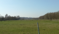
The capital as seen from the IC 7 at Brandhoek, Itegem. -
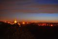
Heist by night. -
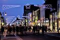
The Bergstraat, the economic heart of the capital, during the 2016 special winter shopping weekend.


Media
- Sunset in Heist-op-den-Berg Featuring: the observation tower (beneath) / ward Hoogbergbossen (beneath) with the Hoogberg forest (beneath/east) / the other two towers (west) / aerial view on the municipality of Hallaar (north) / aerial view on wards Berghovens (southeast) and Schaffelberg (south) / small parts of the IC 1 (south) / ward Slagvelden (northwest) / the Grote Nete valley (northeast).
- The three towers of Heist-op-den-Berg
- At the northern state border Featuring: an 80 m (260 ft.) high Belgian TV antenna / the river Wimp, also the state border / the IC 5 and IC 5 border crossing / the rural hamlet Wimpel.
- HeistLeeft A Belgian newsagency focusing mainly on news out of the little Republic.
- Nature development project in Itegem Poplar trees growing on the shores of the Goorloop stream in Bernum are cut down in favor of multiple endemic species.
- Hof van Riemen Hof van Riemen is one of many historic fortified farms in the Republic. It's located south of the city centre. The farm is at least 550 years old and there's archaeological proof that the area surrounding the farm was Heist-op-den-Berg's first human settlement. Now used as a restaurant.
- Bus 513 on Belgian/Hestian territory This slow tv-like Youtube clip gives an impression of the complete IC 23 going from the border crossing at the Wimp river and a part of IC 4 (28:13 onwards). The Grote Nete river is passed at 27:30. The Village centre of Hallaar at 30:35. Bergstraat, the commercial heart of the city of Heist at 33:08. Station of Heist at 37:12.
- Bus 510 on Belgian/Hestian territory This trip starts at the IC 12 Border crossing. Via Bruggeneinde the Grote Nete river is crossed at 55:24. At 57:49 the church and town hall of Hallaar are visible, after which the bus takes about the same route as bus 513 up to the station. After waiting at the station, the trip continues via IC 1 and the bridge over the railway (1:05:50). 1:08:14 is the roundabout of the IC 1/IC 2 crossing, shortly after the bus leaves the country (1:09:34).