Hestavagr
Hestavagr | |
|---|---|
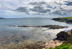
 Hestavagr viewed from United Kingdom. | |
| Country | Jarldom of Hjalvik |
| District | Vestfold |
| Established | 6 September 2020 |
| Government | |
| • Type | Monarchy |
| • Jarl | Jarl Juvan I |
| • Jarl | Jarl Keaghan I |
| Area | |
| • Total | 0.00012 km2 (0 sq mi) |
| Population (2020) | |
| • Total | 0 |
| Time zone | GMT |
Hestavagr is an island territory in the Vestfold district of Hjalvik. The territory is made up of a rocky skerry adjacent to a shingle bay, and has a permanent population of 0.
Etymology
The name "Hestavagr" means "Horse Voe" or "Horse Bay" in Hjalsk. The name comes from the geographical English name for the bay; "Hesti Geo". The name of the peninsula of Hesttunga translates to "Horse Ness" or more specifically "Horse Tongue", due to the word "Tunga" deriving from the same word as "Tongue". The name "Hesteyr" referring to the shingle tombolo connecting Hestavagr to the Orkney isle of Hrossey, derives from the fact the island is joined by a stony ayre to the shoreline.
History
Hestavagr was officially declared part of Hjalvik on 6 September 2020. It was discovered on a colonisation mission, out on the coast of Vestfold. When colonised, it officially became a port for naval training.
Geography
Hestavagr consists of a small skerry made up of red sandstone, with small patches of turf on the top. The rocks are usually coated with seaweed, sometimes making them slippery after the tide has recently gonna out. The island is accessible by walking along a natural causeway, made up of a shingle ayre, known as Hesteyr, connecting the island to the Orkney mainland of Hrossey.

The island has a large peninsula facing east, known as Hesttunga. At high tides this peninsula is sometimes cut off to form a separate island. At unusually low tides, Hestavagr is completely joined to the shoreline by a bed of sand and bladderweed surrounding the ayre.
Hestavagr is the second largest naval port in Hjalvik. It is often used for training purposes, as it leads directly into the sheltered natural harbour of Scapa Flow.
