First Republic of Aksana
This article refers to a micronation or element of micronationalism which is defunct and no longer exists. You can help make the article reflect that or ask on the talk page for further information. |
First Republic of Aksana | |||||||||||
|---|---|---|---|---|---|---|---|---|---|---|---|
| 2022 | |||||||||||
| Motto: "Long live our free snowy wonderland" | |||||||||||
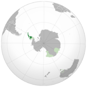
 Location of First Republic of Aksana (dark green) in UAM (light green) | |||||||||||
| Status | disbanded | ||||||||||
| Capital and largest city | Northern Adelaide | ||||||||||
| Official languages | English, Belaksanan, Chinese | ||||||||||
| Recognized languages | English, Spanish, Belaksanan, Chinese | ||||||||||
| Demonym(s) | Aksan | ||||||||||
| Membership | Union of Antarctic Micronations | ||||||||||
| Government | Unitary semi-presidential republic | ||||||||||
• President | Grant Taylor | ||||||||||
| Legislature | Supreme Council | ||||||||||
| Area | |||||||||||
• Total | 58,116 sq mi (150,520 km2) | ||||||||||
• Citizenship | 5 | ||||||||||
| Currency | Argentine peso (ARS) EU Euro (EUR) US Dollar (USD) | ||||||||||
| Time zone | UTC-3:00 | ||||||||||
| |||||||||||
| |||||||||||
| Part of a series on |
| The Republic of Aksana |
|---|
| File:Republic of Aksana Seal.png |
Aksana, officially the Republic of Aksana was an Antarctic unrecognized nation making it a micronation founded by the United New England Micronations Secretary-General on August 25, 2022 as a Unitary semi-presidential republic North of Kingdom of Eintrachtia. Known for its icy land and icebergs and snow, spending half the year in Summer in day and Half the year in winter at night. Claiming sea and land territory of 58,116 sq mi combined[1] of argentine claims of antarctica where the Spanish language comes from in Aksana, on the tip of the Antarctic continent.
Etymology
"Aksana" meaning of this name is "Great Ritual". Based on numerology value 2, Aksana is Cooperative, Sensitive, Adaptive, Passive, Diplomatic, Peaceful, Warm, excellent partner, kind, balance, friendly, tactful and diplomatic, the name Aksana is also a Tamil Girl name of Ukrainian origin.
History
Founding
The Republic of Aksana formed on August 25, 2022 3:40PM planned to request to join the Union of Antarctic Micronations, formed by the United New England Micronations as a Free independent micronation within the Antarctic Continent north of the Kingdom of Eintrachtia recognizing it as a independent state because of its connected borders.
Government
The Republic of Aksana is currently ruled by a President, Prime Minister, and Chairman of the Supreme Council also called the Aksana Council, planning to switch into a Full Unitary presidential constitutional republic within the month of September or October
Political Parties
Aksana only has two political parties, The Political parties of Aksana are the" Aksan Social democratic Party" which is the socialist party of Aksana, and the "Aksana Democratic Party" which is the current ruling party of Aksana. Aksana has zero Third Parties.
Foreign relations

Mutual recognition
Other Relations
![]() Arcadia is recognized as a terrorist state
Arcadia is recognized as a terrorist state
Organizations
![]() Union of Antarctic Micronations
Union of Antarctic Micronations
Life, Geography, and Geology
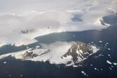
The Aksan geography is cold and frozen but has some Science camps located in its northern points and on northern Adelaide island and has some rocky points, The western portion of Adelaide Island is covered by the Fuchs Ice Piedmont. The Antarctic Peninsula is part of the larger peninsula of West Antarctica, protruding 1,300 km (810 miles) from a line between Cape Adams (Weddell Sea) and a point on the mainland south of the Eklund Islands. Beneath the ice sheet that covers it, the Antarctic Peninsula consists of a string of bedrock islands; these are separated by deep channels whose bottoms lie at depths considerably below current sea level. They are joined by a grounded ice sheet. Tierra del Fuego, the southernmost tip of South America, is about 1,000 km (620 miles) away across the Drake Passage, it is 522,000 square kilometers (202,000 sq mi) in area and 80% ice-covered.


The marine ecosystem around the western continental shelf of the Antarctic Peninsula (WAP) has been subjected to rapid physical climate change. Over the past 50 years, the warm, moist maritime climate of the northern WAP has shifted south. This climatic change increasingly displaces the once dominant cold, dry continental Antarctic climate. This regional warming has caused multi-level responses in the marine ecosystem such as increased heat transport, decreased sea ice extent and duration, local declines in ice- dependent Adelie penguins, increase in ice-tolerant gentoo and chinstrap penguins, alterations in phytoplankton and zooplankton community composition as well as changes in krill recruitment, abundance and availability to predators.
Antarctica was once part of the Gondwana supercontinent. Outcrops from this time include Ordovician and Devonian granites and gneiss found in the Scar Inlet and Joerg Peninsula, while the Carboniferous-Triassic Trinity Peninsula Group are sedimentary rocks that outcrop in Hope Bay and Prince Gustav Channel. Ring of Fire volcanic rocks erupted in the Jurassic, with the breakup of Gondwana, and outcrop in eastern Graham Land as volcanic ash deposits. Volcanism along western Graham Land dates from the Cretaceous to present times, and outcrops are found along the Gerlache Strait, the Lemaire Channel, Argentine Islands, and Adelaide Island. These rocks in western Graham Land include andesite lavas and granite from the magma, and indicate Graham Land was a continuation of the Andes. This line of volcanoes are associated with subduction of the Phoenix Plate. Metamorphism associated with this subduction is evident in the Scotia Metamorphic Complex, which outcrops on Elephant Island, along with Clarence and Smith Islands of the South Shetland Islands. The Drake Passage opened about 30 Ma as Antarctica separated from South America. The South Shetland Island separated from Graham Land about 4 Ma as a volcanic rift formed within the Bransfield Strait. Three dormant submarine volcanoes along this rift include The Axe, Three Sisters, and Orca. Deception Island is an active volcano at the southern end of this rift zone. Notable fossil locations include the Late Jurassic to Early Cretaceous Fossil Bluff Group of Alexander Island, Early Cretaceous sediments in Byers Peninsula on Livingston Island, and the sediments on Seymour Island, which include the Cretaceous Extinction.

