Baltian sector
This article needs editing for compliance with MicroWiki's Manual of Style. |
| Baltian Sector | |
|---|---|
 | |
| General information | |
| Located | Europe |
| Total population of sector | 39,439 |
| Total area of sector | 100.611 km² |
| Membership | |
| Nations in area | 3 (excluding England, not culturally associated with Baltian sector) |
The Baltian Sector, also known as the Baltian States is an area which contains the micronations of Cheslovia, Malokaz, Ud Mahazar. The name of the area is to be used in a way similarly to which the names "Balkan" or "Baltic" is used, for example, one could say The Balkan States instead of Serbia, Bulgaria or Croatia etc. Baltian sector is an area enclosed between three main highways (including one motorway): A34, A40 and the M40. Until the 27th June 2009, Baltian micronations were unaware of the existence of other "Sectors".
Nations
The United Kingdom
The United Kingdom is almost always not associated with Baltian sector due to differing cultures, Baltian culture is heavily influenced by eastern European cultures whereas English culture is one of many western European cultures. The UK also has difering political ideologies compared to Baltian nations.
| Countries of the Baltian Sector | |||||||
|---|---|---|---|---|---|---|---|
| Flag | Name of country | Capital city | Population | Leader | Date of foundation | ||
| 1 |  |
Cheslovia (Cheslovian Federation) | Musorov | 122 | Urosh Dushanov | 11 March 2003 | |
| 2 |  |
Malokaz (Principality of Malokaz) | Kaniv | 6 | Artur Voyislav | 20 June 2008 | |
| 3 |  |
Ud Mahazar (Kingdom of Ud Mahazar) | Bzuodemen | 6 | Zarniq Hutanev | 13 June 2009 | |
Past nations
Baltia has been home to many past micronations, here are the main micronations:
- The Empire of Chivaliers (circa. April 2006 - 25 December 2006)
- The Empire of Zagoria (circa. June 2006 - 25 December 2006)
- The Noke Clan (also known as the Noke Clan) (11 March 2003 - circa. april 2007)
- The Tribe (associated with Baltian sector, not situated inside Baltian sector) (circa. 1997 - 11 March 2003)
Geography
Baltian sector is located between the M40, A34 and A40, there are two main rivers in Baltian sector the Talimaa river and the Volgov river, the Volgov is a river that branches off the Talimaa. North of both the Talimaa and Volgov rivers is the area called Vyach but also known as "Gryushi Mnoga Baltiya", Cheslovian for "Near Much/Main Baltian sector". To the east of Talimaa river is "Kluyvliya Baltiya", Izkargom for "Little Baltiya" and finally the main area of Baltian sector called "Mnoga Baltiya", Cheslovian for "Much/Main Baltian sector". Northern baltia must not be confused with Vyach, Northern Baltian sector is defined by political division as of January 1, 2009, although Northern Baltian sector is located in Vyach. The landscape of Baltia has been given "Baltian names", names that sound Slavic/Russian. For example, the Talimaa river is known in England as the Cherwell river, but in Baltian sector it is known as Talimaa etc.
Greater Baltian sector lies towards the east of Baltian sector, it is not generally considered to be part of Baltian sector.
Symbols
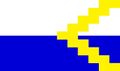
Baltian sector has only two main symbols, the "Baltian Zigzag" and the flag of Baltian sector (the flag of the BCSA is not considered a symbol of Baltian sector, as it represents an organisation, not the area).
The Baltian Zigzag
The Baltian zigzag gradually emerged as a symbol of Baltian sector during 2008, it is not known why or how the zigzag was chosen, and there are various meaning as to what it represents, including:
- The zigzag represents the unrecognised nations of Baltian sector (a reference to the unrecognised nation of Nagorno-Karabakh)
- The zigzag points to western Europe, towards other Russian/Slavic style nations which are not situated in Eastern Europe (eg. Nemkhavia)
- The zigzag represents the Cheslovian territories not situated inside Baltian sector (many of them are situated west, the same direction as the zigzag points)
There is no official meaning to the zigzag.
-
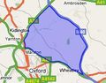
A map of Baltian sector
-
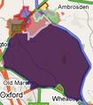
A map of Baltian sector showing all three Baltian micronations, as well as some highly influential Baltian Rebel Organisations
-

The flag of Baltian sector, 2009 - Onwards
-
The flag of the BCSA
-

Historical flag of Baltian sector, used for a short time during mid 2009
-

Historical (the first) flag of Baltian sector (2008 - 2009)


