Nomadic Limonia
Federation of Limonia | |
|---|---|
| Motto: "Limonia is freedom, and our land!" | |
 | |
| Capital and largest city | Digital Administrative Region 21°52′9″N 33°44′52″E / 21.86917°N 33.74778°E |
| Official languages | Portuguese[a] |
Other languages | English and Spanish |
| Ethnic groups | Italian, German, Brazilian, Portuguese |
| Demonym(s) | Limonian |
| Government | Constitutional parlamentarist |
| Deivisson Gabriel Floriano | |
| Elias Arquimedes | |
| Legislature | Legislative Council |
| Network state | |
| Area | |
• Total | 946.435 km2 (365.421 sq mi) (168th) |
• Water (%) | 8.6 |
| Population | |
• Estimate | 10 |
• Density | 001/km2 (2.6/sq mi) |
| GDP (PPP) | $1 million estimate |
• Total | $1 million |
• Per capita | $1,000.00 |
| GDP (nominal) | estimate |
• Per capita | $1,000.00 |
| HDI (2023) | ▲ 0,758 Error: Invalid HDI value |
| Currency | Limones Digital Coin (LDC) |
| Time zone | UTC-3 (UTC-3) |
| Date format | dd/mm/yyyy |
| Driving side | right |
| Calling code | +80 |
| Internet TLD | .ln |
Nomadic Limonia, officialy Federation of Limonia, is a network state founded in 2021. The Federation of Limonia, is a digital society developed with the intention of guaranteeing the rights, liberty and privacy to the individual, where he has its own protocols and regulations without depend on countries or governments.
Geography
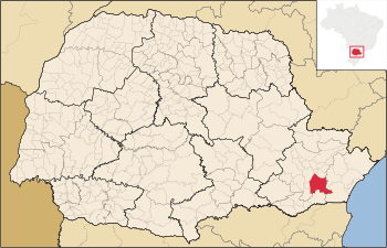
The network state is located in the Metropolitan Region of Curitiba, having as limits: Pinhais and Piraquara to the north; Tijucas do Sul to the south; Morretes and Guaratuba to the east; Curitiba, Fazenda Rio Grande and Mandirituba to the west. Its headquarters is marked by the following coordinates: 25º32'06" South latitude and 49º12'21" West longitude of the Greenwich meridian, connecting to the state capital, through BR-376 in a course of 7 km. The municipality's territory comprises an area of 931.73 km².
Geologically, the municipality's lands are of Quaternary-Pleistocene, Quaternary-Holocene, Archean-Proterozoic, Proterozoic-Cambrian, Paleozoic-Cambrian and Mesozoic-Jurassic-Cretaceous origin. The soil types in the municipality are melanic gleissolo, mesic organosolo, bruno-latosol, red-yellow argissolo, red latosol, cambisolo háplico, rock outcrops, and red-yellow latosol.
The altitude is 906 meters, at the municipal seat. The relief of the municipality is formed by the Iguaçu river valley to the west and the Serra do Mar mountain range to the east, with altitudes ranging from 200 m to 1,300 m. São José dos Pinhais is located between the First Paraná Plateau and the Serra do Mar.
Limited access
The telecommunications and private internet network can only be accessed within the Limonian territory. Limonia has its sovereignty even in digital media, where it has its own authorative dns server to manage the Limonian internet network.
Government
According to the Constitution "Liberty", written in 2022 by the Federation of Limonia, the government must respect social differences, individuals and their freedom. It is a constitutional government, where it is composed of a Prime Minister, Ministers, Legislative Power and Judiciary Power.
Citizenship
Limonian citizenship can be granted by investment, naturalization and marriage. Every ethnicity, creed and people can apply for the citizenship of the Federation of Limonia.
Taxes
Federation of Limonia is completely free, with no taxes or fees included.
National symbols
The flag of Limonia is a horizontal tricolor in green, white and blue.
Climate
The Federation of Limonia has a humid subtropical climate type Cfb, with an average annual temperature of 20°C.
The lowest temperature recorded in the city was -6°C, on July 18, 1975, and the highest was 35.5°C on October 2, 2020. In winter, especially in June and July, the maximum temperature hardly exceeds 20°C and the minimum temperature can reach 0°C. Frost is common in these months, but snow is very rare (the last time was in July 2013).
| Climate data for Federation of Limonia | |||||||||||||
|---|---|---|---|---|---|---|---|---|---|---|---|---|---|
| Month | Jan | Feb | Mar | Apr | May | Jun | Jul | Aug | Sep | Oct | Nov | Dec | Year |
| Average high °C (°F) | 25.6 (78.1) |
25 (77) |
23.3 (73.9) |
21.3 (70.3) |
18.6 (65.5) |
18.4 (65.1) |
19 (66) |
20.2 (68.4) |
21.4 (70.5) |
22.9 (73.2) |
24.3 (75.7) |
23.9 (75) |
21.99 (71.59) |
| Average low °C (°F) | 16 (61) |
15.8 (60.4) |
13.9 (57) |
11.2 (52.2) |
8.4 (47.1) |
7.8 (46) |
8 (46) |
9.3 (48.7) |
11.2 (52.2) |
12.9 (55.2) |
14.2 (57.6) |
13.8 (56.8) |
11.9 (53.4) |
| Source: MeteoBlue.com[1] | |||||||||||||
References
- ↑ "Weather for Bir Tawil". MeteoBlue.com. Retrieved 6 November 2019.

