Booth Island
| Booth Island Бутово Острво Butovo Ostrvo | |
 Flag | |

| |
| Official languages | Weisslandic, English, Serbian, |
| Government | Non-sovereign democracy with unelected executive |
| Established | |
| – June 1, 2010 | (as a part of the State of the People of West Antarctica) |
| Time zone | CET (UTC+1); Summer (DST) CEST (UTC+2) |
| Internet TDL | .wa (proposed) |
| Calling code | +699 (proposed) |
Booth Island is an administrative unit of the State of the People of West Antarctica. It became a part of the State on March 21, 2010 after the dissolution of its previous owner, United Antarctica Colonies.
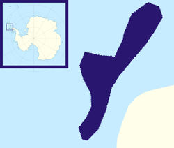
The island (also called Wandel Island) is a rugged, Y-shaped island, 5 miles long and rising to 980 m, off the west coast of the Antarctic Peninsula in Antarctica in the northeastern part of the Wilhelm Archipelago. Booth Island is located at 65.08°S 64.0°W. Discovered and named by a German expedition under Eduard Dallmann 1873-1874, probably for Oskar Booth or Stanley Booth, or both, members of the Hamburg Geographical Society at that time. The Advisory Committee on Antarctic Names has rejected the name "Wandel Island", applied by the Belgian Antarctic Expedition, 1897-1899, in favor of the original naming. The narrow passage between the island and the mainland is the scenic Lemaire Channel.
The highest point of the island is 980-meter Wandel Peak, as of 2003 still unattained despite several attempts.
