Dooneen Cove Island
Dooneen Cove Island
Oileán Cúis an Dúinín | |
|---|---|
Territory of Leylandiistan & Gurvata | |
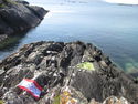
 A view of Dooneen Cove Island from the mainland. | |
 Flag  Seal | |
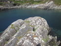
 An aerial view of Dooneen Cove Island | |
| Confederation Territory | Uninhabited territory |
| Annexed | 7 September 2014 |
| Area | |
| • Total | 0.00375 km2 (0.00145 sq mi) |
| • Land | 0.0011 km2 (0.0004 sq mi) |
| • Water | 0.00265 km2 (0.00102 sq mi) Estimate: 70% *% |
| Elevation | 2 m (7 ft) |
| Population (September 2014) | |
| • Total | 0 |
| Time zone | UTC+0 (GMT) |
| (* Please note: Water area is de facto controlled as it surrounds island, the water area has not been officially claimed) | |
Dooneen Cove Island is an island which was formerly under the jurisdiction of the Confederation of Leylandiistan and Gurvata for much of that nation's existence. It is located on the coast north-west of Allihies, Co. Cork, Ireland. It is an uninhabited territory.

History
The townland of Dooneen on the north coast of the Beara Peninsula is isolated and and surrounded on one side by the Caha Mountains and on the other by the Atlantic Ocean. The population density is very low and the land unsuitable for most types of farming. Like most rural Irish areas, the Great Famine of the 1840's caused most of the population to emigrate elsewhere. At the side of Dooneen Cove is a small building known as the Old Forge, a building which may in the past have offered blacksmith services to the local area.
Dooneen Cove Island is not listed on any historical records or outlined on any maps because it is considered too small and too close to the mainland to be considered an offshore islet. It was never inhabited at any stage because the land is too small and exposed to build any sort of dwelling. The name Dooneen Cove Island was given to it first by the Confederation of Leylandiistan & Gurvata before the annexation when it was discovered the island had no official name. It was given this name because it is the only inshore islet in Dooneen Cove. The word Dooneen is an anglicisation of the Irish term "Dúinín", meaning "little fort". This name in itself was considered appropriate for the island because it is a lone outpost of the Confederation, surrounded by mountains and the Atlantic Ocean.

The Co-President representing Leylandiistan in the diarchical executive, Fionnbarra Ó Cathail, was travelling north from Allihies to Reenfrisk on 7 September 2014 when the road brought him past Dooneen Cove. A quick inspection of the strand led him to the island connected to it by a concrete walkway. With flag in hand Ó Cathail composed the Declaration of Annexation, which declared that the island was now under the jurisdiction of the Confederation of Leylandiistan & Gurvata. The Declaration was put into a plastic bottle, hidden in a depression in the centre of the island and covered with flat rocks to prevent it washing away or being weathered. The flag was raised on the island by hanging it from a fishing rope suspended from the island's steep rocky shore. Dooneen Cove Island's annexation was officially acknowledged and legally authorised by the Annexation of Dooneen Cove Island Act, passed a fortnight later as the first item of legislation in the Confederation's history.
On 23 September 2015, a return visit to the island was made by Ó Cathail. A border sign was erected[1] at the point where the causeway meets the island. A bridge, consisting of a pallet with rocks underneath to support it, was also erected over a long narrow depression in the middle of the island. The following day, when it was discovered the Declaration of Annexation had been taken from the island, a copy of the Annexation of Dooneen Cove Island Act was placed in a bottle and hidden in a the rocks on the north coast of the island.
Geography
The island is located in a small rocky cove on the north coast of the Beara Peninsula, County Cork, Ireland. The nearest settlement is the village of Allihies. It is about one metre offshore, and is at low spring tides connected to the mainland. An L-shaped concrete causeway which is about 5 metres long and one metre wide connects the island to the mainland, though it is presumed this causeway was originally built as a dock for small vessels, or to stop the sea from washing the natural stone cover of Dooneen Cove strand away.
Gallery
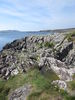
Areas of Dooneen Cove Island
-
The border sign at the point where the causeway meets the island
-
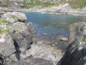
Rocky Cove, a shallow sheltered cove on the north coast of the island.
-
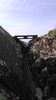
The bridge erected in September 2015
-
The interior of Dooneen Cove Island has scatterings of wild flowers, small stagnant pools and bare grass cover
-
Flag Head, the southwestern-most point of Dooneen Cove Island
-
The northernmost point of the island, marked with a metal pole


The areas above may be found on this map published by the Ordnance Survey of Leylandiistan & Gurvata. The map in question was the first edition and is not set to any particular scale.
References
| General | |||||||
|---|---|---|---|---|---|---|---|
| Predecessors | |||||||
| Government |
| ||||||
| Media | |||||||
| People | Fionnbarra Ó Cathail • Pádraig Ó Ceocháin | ||||||
| Places |
| ||||||
| Organisation Membership | |||||||