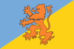
Crowntonese Marshoa
Crowntonese Marshoa | |
|---|---|
| Motto: Only the strong may be allowed | |
| Status | Active |
| Capital and Population | Atollance |
| Official languages | English |
| Recognised national languages | English |
| Demonym(s) | Marshoan |
| Government | |
• President | Ranel I |
| Legislature | Presidential |
| House of Marshoa | |
| Territory | |
• Established | 26 July 2020 |
| Area | |
• | 1.081 sq mi (2.80 km2) |
| Population | |
• Estimate | 1 Global Citizen |
| Currency | United States dollar (USD) |
| Time zone | Greenwich Mean Time (GMT +12) |
| Calling code | +1 (862) |
Crowntonese Marshoa is unincorporated territory of Crownton, it is in Oceania and on Ailinginae Atoll, more specifically in the Marshall islands. Crownton Marshoa has 0 residents, but has 1 global citizen that being Ranel Lopez. Crowntonese Marshoa was made on July 26, 2021. Crowntonese Marshoa is an important part of Crownton as it's not really known, this is part of Ranel's plan of going to Crowntonese Marshoa if both Crownton and Kvitoya get attacked. Also Crowntonese Marshoa is located on the Oceanic island chain, the Narshoan islands, which is in the Marshall islands, a country in Oceania.
History
Ailinginae Atoll
The first sighting recorded by Europeans was by the Spanish navigator Álvaro de Saavedra on 1 January 1528. Together with Utirik Atoll and Rongelap Atoll, they were charted as Islas de los Reyes (Islands of the Three Wise Kings in Spanish) due to the proximity of Epiphany
Ailinginae Atoll was claimed by the Empire of Germany along with the rest of the Marshall Islands in 1884. After World War I, the island came under the South Seas Mandate of the Empire of Japan. Slade Lee later claimed Ailinginae Atoll along with Rongelap Atoll to create Marshoa, but then Slade thought that it would be unnecessary space so he disowned Ailinginae Atoll. Ailinginae Atoll has been uninhabited since 1954, until July 26, 2021, when Ranel decided to claim the island as territory of Crownton.
Relations with Marshoa
Crowntonese Marshoa and Marshoa make up the Marshoan islands, Crowntonese Marshoa use to actually be part of Marshoa, but then Slade Lee thought that it was unnecessary space so he disowned it. Ranel Lopez and Slade Lee negotiated about owning Ailinginae. After an hour of talking Slade gave Ranel full control of Ailinginae Atoll, which would later become Crowntonese Marshoa. Crownton would join the Marshoan Union which was a trade agreement with Marshoa, Crownton and Triloa.
Conflict with Triloa
Triloa is another micronation in the Marshoan Islands and since it's beginning, it has been in the Marshoan Union along with Marshoa. When Slade Lee disowned Ailinginae Atoll Kingsley Angste (King of Triloa) was worried because she knew that any micronation could take it as theirs, so Kingsley decided that she was gonna own Ailiginae Atoll in a couple days.
Then that opportunity was taken as Ranel Lopez would take it has his. Kingsley wasn't happy so she told Slade that se was going to leave, but then after negotiating with one another they agreed that Ranel would've been a minor nation in the Marshoan Union.
Climate
| Climate data for Majuro | |||||||||||||
|---|---|---|---|---|---|---|---|---|---|---|---|---|---|
| Month | Jan | Feb | Mar | Apr | May | Jun | Jul | Aug | Sep | Oct | Nov | Dec | Year |
| Average high °F (°C) | 85.5 (29.72) |
85.9 (29.94) |
86.1 (30.06) |
86.1 (30.06) |
86.4 (30.22) |
86.3 (30.17) |
86.4 (30.22) |
86.7 (30.39) |
86.9 (30.5) |
86.9 (30.5) |
86.6 (30.33) |
85.9 (29.94) |
86.3 (30.17) |
| Average low °F (°C) | 77.8 (25.44) |
77.9 (25.5) |
78.0 (25.56) |
78.1 (25.61) |
78.3 (25.72) |
77.9 (25.5) |
77.8 (25.44) |
77.9 (25.5) |
77.9 (25.5) |
77.8 (25.44) |
77.9 (25.5) |
77.7 (25.39) |
77.9 (25.5) |
| Average Precipitation inches (mm) | 8.28 (210.3) |
7.62 (193.5) |
7.55 (191.8) |
9.63 (244.6) |
9.86 (250.4) |
10.93 (277.6) |
11.93 (303) |
11.42 (290.1) |
12.14 (308.4) |
13.27 (337.1) |
13.23 (336) |
11.56 (293.6) |
127.42 (3,236.5) |
| Average relative humidity (%) | 77.7 | 77.1 | 79.0 | 80.7 | 81.9 | 81.1 | 80.5 | 79.3 | 79.4 | 79.4 | 79.9 | 79.7 | 79.6 |
| Average precipitation days (≥ 0.01 in) | 19.3 | 16.1 | 17.6 | 18.9 | 22.1 | 23.1 | 24.3 | 22.9 | 22.9 | 23.4 | 22.9 | 22.7 | 256.2 |
| Sunshine hours | 224.4 | 218.6 | 252.8 | 219.4 | 224.8 | 210.8 | 217.0 | 232.2 | 217.8 | 205.4 | 191.4 | 197.4 | 2,612.0 |
| Source: NOAA (relative humidity and sun 1961−1990)[1][2] | |||||||||||||
- ↑ "MH Majuro WBAS AP". National Oceanic and Atmospheric Administration. Retrieved 11 March 2015.
- ↑ "WMO climate normals for Majuro, PI 1961−1990". National Oceanic and Atmospheric Administration. Retrieved 11 March 2015.

