Commonwealth of St. James Islands
Commonwealth of St. James Islands
| |||
|---|---|---|---|
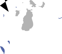
 Map of St. James Islands, claims in blue | |||
| Capital and largest city | Isabelle | ||
| Official languages | English, French | ||
| Demonym(s) | Sainter | ||
| Government | Colonial | ||
• Monarch | Aidan I | ||
| vacant | |||
| Tyler Boyle | |||
| Legislature | Parliament | ||
| Senate | |||
| House of Commons | |||
| Independence from the Kingdom of Quebec | |||
• Dominion created | 4 May 2019 | ||
• Independence | 5 July 2019 | ||
| Area | |||
• Total | 9.26 km2 (3.58 sq mi) | ||
• Water (%) | 7% | ||
| Population | |||
• Estimate | 27 | ||
• Density | 8/km2 (20.7/sq mi) | ||
| Currency | Québécois Dollar (QD; $) | ||
| Time zone | UTC-5 (EST) | ||
• Summer (DST) | UTC-4 (EDT) | ||
| Date format | mm-dd-yyyy; AD | ||
| Driving side | right (Fox Islands and Ile Aux Galets), left (Trout) | ||
| Calling code | +1 | ||
The Commonwealth of St. James Islands, most commonly know as St. James is a former Dominion of the Kingdom of Quebec and which claims consist of, the Fox Islands, Gull Island, Trout Island, and Ile Aux Galets. The Dominion was formed after Fox Islands dispute between the Kingdom of Quebec and the Kingdom of Baustralia, ended after the Kingdom received the Islands back on 1 May 2019.
Etymology
The name Saint James comes from James, son of Zebedee, who was one of the Twelve Apostles of Jesus, traditionally considered the first apostle to be martyred. It is also named for a town near the Islands named St. James Township.
North Fox Island

In the 1960s and 1970s, a child pornography ring was discovered operating on North Fox Island. The proprietor of the island, Francis Shelden, used his position in a large social program called the Brother Paul's Children's Mission, as well as his position as a Big Brother with the YMCA in Ann Arbor, to fly boys in his private plane to his island retreat. The Ann Arbor News published a story in their weekend magazine on the proprietor's life, then published a second story when the crimes were uncovered. The crimes have long been suspected to have ties to the Oakland County Child Killer case.
It is home to the HMRAS Beechside Air Service staion.
South Fox Island History
Two generations of the South Fox Island Light stand at the southern extremity of the island. The first, built in 1867, is a brick house with attached tower; the second, a skeletal tower, is the former Sapelo Island Light, which was moved to the site in 1934. The Fox Island Lighthouse Association, a non-profit organization, was formed in 2004 to aid in preservation of the light station structures.
South Fox Island boasts some of the most spectacular freshwater maritime scenery in the world, including towering dunes, virgin cedars, and untouched beaches.
The island includes a cemetery where members of the Grand Traverse Band of Native Americans are currently buried.
Deer were introduced onto the island in 1915. Hunting is permitted on state land by permit only.
It currently is home to the capital and the largest airport in the Islands, Saint James Airport.
Gull Island History

Gull Island or Lonely Gull Island is located 7 miles west of High Island, which is itself uninhabited. It is the largest of the four Lake Michigan islands in the Michigan Islands NWR, and the only one to have a substantial forest ecosystem. Balsam fir and northern whitecedar grow in the island's humid, boreal climate. Gull Island also has beaches and sand dunes on its north and east sides.
On November 18, 1958, the SS Carl D. Bradley, a cargo vessel, foundered and sank 12 miles southwest of Gull Island, with a loss of 33 of the 35 men aboard.
It is currently the only island with zero activity noted.
Trout Island History

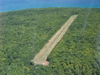
Trout Island is an island in Lake Michigan the island is 80 acres in size. There is an airstrip on the island that extends across the whole island to both shorelines. Trout Island is a little under two miles from High Island, and a little over six miles from Beaver Island.
Little is know about the Island, expect for the fact that it is currently home to the HMRAS Courage Air Service staion.
Ile Aux Galets
Ile Aux Galets, strangely the only island for miles with a french name, also known as Skillagallee or Skillagalee Island, is located in northeast Lake Michigan, between Beaver Island and the mainland, approximately 7 miles (11 km) northwest of Cross Village in Emmet County. The island's Ile Aux Galets Light warns passing ships of a dangerous gravel shoal extending almost 2 miles
The islet is home to a significant colony of ring-billed gulls. Its name, given by early French explorers, means "Isle of Pebbles." It is said that the English speakers found the French name unpronounceable, and "Ile aux Galets"—soon misheard, misunderstood and mispronounced—transmuted into "Skillagalee" (or some variant) which took hold. By the "mid 1800's references to the original French name all but disappeared.

There are many wrecks near Skillagalee island. However, on September 27, 1850, the loss of the A.D. Patchin—a wood sidewheeler, 226 feet (69 m) long and built in Trenton, Michigan in 1846—led to the construction of the first light on the island. Loaded with general goods, the Patchin's course into Grays Reef Passage was disrupted by currents that pulled her onto Skillagalee's shore. Her crew escaped and was rescued, but foul winds and weather thwarted many attempts to set her free. She was "pounded to pieces, becoming yet another of Lake Michigan's many shipwreck victims.

