United Empire of Bakhetia and Portasia
This article needs more links to other articles to help integrate it into the encyclopedia. (September 2022) |
This article contains information pertaining to a fictional micronation, micronationalist or other fictional element of micronational society or culture. |
United Empire of Bakhetia and Portasia | |
|---|---|
| Anthem: | |
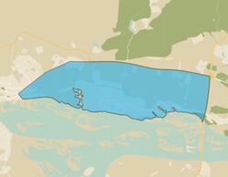
 General map | |
| Capital and largest city | Akabad |
| Official languages | Russian, Tatar, Chuvash, Mari |
| Demonym(s) | Bakhetians |
| Government | Absolute monarchy |
• Emperor | Amir I |
| Establishment | 20 January 2021 |
| Population | |
• Census | 55 |
| Currency | Ruble |
| Time zone | UTC+3 (Moscow) |
| Internet TLD | None |
The United Empire of Bakhetia and Portasia is a micronation in Eastern Europe. It is located on the territory of the village of Vasilevo in the Republic of Tatarstan. The capital of the country is the city of Akabad. The official languages are Russian, Tatar, Chuvash, Mari. The main goals of the State are the preservation of local traditions and culture.
The country is an authoritarian legal virtual state, the power in which completely belongs to the emperor. At the moment, Emperor Amir Khairov is on the throne, despite this, the country's constitution is currently being actively developed, with the adoption of which there should be a change of the state system to a dualistic monarchy.
The state is legal and secular, actively develops foreign and domestic policy. There are official representations of the country in many popular social networks, and the implementation of the goals and objectives of the country's existence is carried out with great speed.
Despite the authoritarian system, the country is socially oriented. It actively protects the interests of its citizens and helps many of them to reveal and show themselves.
Geography
The country is located in the north-west of the Republic of Tatarstan, on the left bank of the Volga River at the mouth of the Bag River, which means that the country is dominated by a flat terrain and a temperate continental climate.
From the south, the country is bounded by the Kuibyshev reservoir, from the north it is bounded by the former Karasikha channel, which in the middle of the XX century was turned into a series of swampy lakes due to the construction of bridges across it.
Terrain
The relief of the country is flat, this is due to its location on the shore, or rather in the valley of the Volga River, which is so huge and wide that its overflow for thousands of years has formed coastal plains, on one of which is located Bakhetiya. The height difference above sea level here is from 49 to 110 meters. The relative elevation is located in the north of the country, where a number of heights from one hundred to 110 meters above sea level prevail. In other places, the heights do not exceed the mark of 70 meters.
Inland waters
The country has no access to the sea, however, it is equivalent to the sea, its functions are taken over by the Volga River, which is the southern border river. The other major river in the country is the Bag River. The Volga is the main waterway of the country and the region. Tourist and commercial shipping is carried out along it, fishing is developed. The Volga connects the country with the sea (you can get to the Azov and Caspian Seas by the river.
There are no large reservoirs in the country.
Climate
The climate is moderately continental (according to Alisov), moderately continental humid with warm summers, Dfb (according to Köppen), characterized by warm summers and moderately cold winters. The warmest month of the year is July (+19...+21 °C), the coldest is January (-13...-14 °C). The absolute minimum temperature is -44...-48 °C. Maximum temperatures reach +37...+42 °C. The absolute annual amplitude reaches 80-90 °C.
The average amount of precipitation is from 460 to 520 mm. The growing season is about 170 days.
The average annual temperature is about 2-3. 1 °C.
A steady transition of the average daily temperature through 0 °C occurs in early April and at the end of October. The duration of the period with a temperature above 0 °C is 198–209 days, below 0 °C-156-157 days.
The average annual precipitation is 460–540 mm. During the warm period (above 0 °C), 65-75% of the annual precipitation falls. The maximum precipitation falls in July (51–65 mm), the minimum-in February (21–27 mm).
Snow cover is formed after mid-November, its melting occurs in the first half of April. The duration of snow cover is 140–150 days a year, the average height is 35–45 cm.
History
Premicronational history
Vasilevo was founded in the XVII century. According to one version, the village got its name in honor of a famous robber named Vasily, who moved here from the banks of the Vyatka River and once wandered in the local area, robbing merchants passing by. Vasily founded a village here. Translated from the Mari Vasilievo-Vas sola — the village of Vasily.
In 1693, it became part of the Raifa desert. It is known that on the territory of the modern village there were two settlements-Vasilevo and Odintsovo; the latter was located somewhere at the mouth of the Bag, in the area of Kalinin, Lenin and Sportivnaya streets.
Approximately at the turn of the 1850s-1860s, Vasilevo became part of the Ilyinsky parish. In the XIX century, there is a noticeable increase in the population, an economic leap is noticeable at the beginning of the XX century, which is associated with the development of industry and the construction of the railway in 1893. In May 1893, auctions were held for land plots located in the village of Vasilevo near the railway itself (the territory of the current sanatorium "Vasilevsky"). In the summer, merchants lived in the dachas. Since 1894, the dacha committee began to work, the construction of dachas began in 1895. In the same year, 1894, the opening of the Vasilevo railway station took place.
In 1872, the construction of a stone church in honor of the Exaltation of the Holy and Life-Giving Cross of the Lord began in the village of Vasilevo, in which on July 25, 1897 (according to the new style), on the day of the celebration of the icon of the Mother of God "Troeruchitsa", the Divine Liturgy was celebrated by St. John of Kronstadt.
In 1928, Vasilevo became an urban-type settlement.
Until 1938, the village was part of the Arsky canton, in the period from 1938 to 1958 — as part of the Yudinsky district. In 1928, there were 300 houses in the village, there were: 1 outpatient clinic, an elementary school, a rest house for 200-300 people, a glass factory, since 1926-a sawmill. By 1953-1257 houses, microdistricts were opened: "Novy Mir", "Zhilkooperatsiya", "Levanevsky", "Lesokombinat".
Micronational period
On October 24, 2020, the first micronation in these places - Portasia, which is now an integral part of the empire, was founded on the territory of the village. At the time of its foundation, it was decided to locate it on the territories of the exclaves of the Republic of Tatarstan, except for those on the territory of which settlements were located, because of which the country had no capital, and the government of the state headed by Amir Khairov (the current emperor) was located outside its borders. All this provoked the subsequent transfer of the entire country directly to the village of Vasilevo.
The state steadily developed and grew in the period between October 24, 2020 and January 3, 2021, when a turning point in the history of the state occurred. It was then that an unsuccessful attempt was made to hold elections. Among the candidates there were a number of personalities, including A. Moragiev and O. Suschik, who accused the government of Amir Khairov of falsifying the elections. On January 3, Sushchik and Moragiev created a Commandant's office headed by them. In response, Amir Khairov received the title of the Father of the Nation. On January 5, the next presidential election was held, which was won by Sushik, which was contested by Amir Khairov.
On January 14, the League of Independent States issued a decree on the abolition of all micro-national entities on the territory of Portasia, which further aggravated the situation in the country, which split into the Vasilyevsky Kingdom and Portasia. For the sake of ending the troubles, Amir Khairov decided to establish the Vasilievsky Empire, which after a while settled on the half-dead fragments of Portasia, concluding peace with most of them.
By mid-March, a stable state of affairs was established in the country for a while, the country began to develop diplomacy and friendly relations with a number of developed microstates, however, against the background of the Integralist-Ramland conflict, in which Vasilevo (Bakhetiya) supported Ramland, led by Suschik, the country temporarily lost its sovereignty, which was undermined by New Eastland, which declared the country's territories part of its own, however, after the Seven-Day War between Ramland and Suoria, New Eastland was abolished, and Bakhetiya gained independence, which it possesses by this day.
Political structure
Symbols
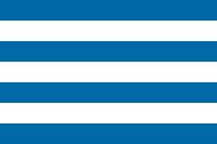
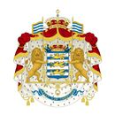
The flag of Bakhetia is a white cloth with four blue stripes. The proportions of the flag are 3:4. The coat of arms of Bakhetia represents a coat of arms with the image of three dragons on the flag of Bakheti, which is located on the mantle. The coat of arms is supported by shield-bearing lions.
Government
The Bakhtin Empire is an authoritarian federal state with an absolute monarchy as a form of government.
The Head of State, the Supreme Commander-in-Chief and the head of the executive, judicial and legislative power is the Emperor of Bakheti and the King of Portasia - Amir.
For most of its history, the country had a Constitution, and the form of government was a presidential republic (until January 20, 2021) and a dualistic monarchy (winter-summer 2021). There was a legislative body in the country, and ministers were also appointed, which provided for various versions of the constitution of the country, but it was temporarily canceled by the decision of the people, and is currently being rewritten.

