Geography of New Eiffel


The geography of New Eiffel, an erstwhile principality and micronation that existed between 31 December 2017 and 1 November 2020, was defined by its location—it was landlocked within the United Kingdom in Europe. Shaped like a rectangle, New Eiffel had an area of 618 square metres (6,652 square feet) and an almost consistently flat terrain with no bodies of water. Having had an average elevation of 15.5 metres (51 ft) above sea level, the micronation experienced a slight elevation of 160 millimetres (6.3 inches) in west Új Repülő, though the extreme points of New Eiffel were generally insignificant as a whole. It was located in the 0th meridian.
New Eiffel was located entirely within the English Lowlands beech forests terrestrial ecoregion, and the principality had several trees. New Finland Monument, a Malus domesticas (apple trees), was a former national monument Grade 2-listed by the New Eiffel Registry Ministry. The geology of New Eiffel consisted of mudstones and sandstones from the Silurian period overlain by Old Red Sandstone from the Devonian period and finally, the London Clay Formation from the Palaeogene period. The subsoil was made up of deposits of alluvium during the Quaternary period, while the soil itself was mostly sandy and clay, causing problems for agriculture. Some areas of the Rugbull Field experienced flooding due to poor water absorption.
New Eiffel had a temperate oceanic climate according to the Köppen climate classification; the climate was cool and often cloudy, and high temperatures were infrequent. New Eiffel was often rainy in autumn, spring and the winter. The average wind speed in the principality was about 18.5 kilometres per hour (11.4 miles per hour). Ecologically, New Eiffel emitted 5.1 tonnes of greenhouse gas emissions (CO₂) per year—below the London average of 8.1 tonnes. A nearby motorway in the surrounding United Kingdom meant that the level of air pollution in the micronation was largely dependent on actions taken by the British. The micronation's Air Quality Index score generally ranged between "Good" and "Moderate."
Area and terrain

The Principality of New Eiffel was a landlocked micronation; enclaved entirely within the United Kingdom of Great Britain and Northern Ireland in Europe. It had an area of 618 square metres (6,652 square feet), sharing 156 meters (511 ft) worth of borders with the macronation. Shaped like a rectangle, New Eiffel had four named borders designated by the four cardinal directions (points of the compass)—the 68.2-metre (224 ft) North and South Borders; the principal, 8.9-metre (29 ft) East Border (nicknamed the "main border"); and the 9.7-metre (31.8 ft) West Border ("back border"), the most fortified.
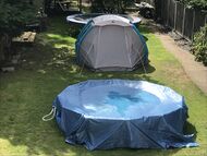
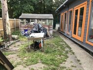
New Eiffel's terrain was consistently flat, except for a slight elevation of 160 millimetres (6.3 inches) in west Új Repülő and a small depression on the J16 in the south of the Rugbull Field, Plitvice near Plitvice Bomb Shelter that always flooded after rain. Most of New Eiffel's terrain consisted of lawn, the Rugbull Field about 160 square metres (1,722 square feet) in size. The portions of ground around or in Dead Tree Lane, New Eiffel School Playground, Unnamed Circle and the Walkway and South Alleyways was largely dirt due to seldom receiving sunlight because of being blocked by large trees or other structures. All the remaining land area in New Eiffel was developed for urban use. New Eiffel had no bodies of water.
Extreme points
The geographical centre of New Eiffel was in the east of the Rugbull Field, and the micronation had an average elevation of 15.5 metres (51 ft) above sea level. The following presents a list of extreme points of New Eiffel: the points that are farther north, south, east or west than any other location, as well as the highest and lowest places. However, due to the small size of the principality, as well as a general lack of change in elevation, the extreme points of New Eiffel were generally insignificant as a whole.
The highest point, at 15.78 metres (51.77 ft), was an elevated pile of dirt separating Unnamed Circle and Northwest Street in Dead Tree Lane, Dead Tree, Új Repülő, near the eponymous tree stump. The lowest was 15.41 metres (50.55 ft), a depression on the J16 in the south of the Rugbull Field, Plitvice near Plitvice Bomb Shelter. It always flooded after rain, further eroding the depression. The northernmost point of New Eiffel was a hedgerow forming the tip of the New Eiffel–United Kingdom North and East borders fronting XCUT Therapy Parking in New Leeds; the principal border crossing into the micronation. Southernmost was the fortified, steel fence forming the New Eiffel–United Kingdom West Border, fronting South Alley in Új Repülő. The easternmost point was another hedgerow forming the tip of the New Eiffel–United Kingdom East and South borders fronting XCUT Therapy Parking, while the westernmost point of the micronation was once again the fortified, steel fence of the West border, fronting Walkway Alley.
Physical geography
Geology
The oldest rocks beneath New Eiffel were Palaeozoic (538 to 251 million years ago—Mya), consisting of mudstones and sandstones from the Silurian period (443 to 419 Mya), overlain by Old Red Sandstone from the Devonian period (419–358 Mya) and finally, the London Clay Formation from the Palaeogene (66–23 Mya) period. Specifically, the sedimentary bedrock in the London Clay was formed between 56 and 47 Mya. The subsoil was made up of deposits of alluvium during the Quaternary period (2.58 Mya to present). New Leeds and most of Új Repülő consisted of sedimentary superficial deposits formed between 11,800 and 400 years ago, while Plitvice and the easternmost edge of Új Repülő consisted of sedimentary superficial deposits formed between 2.58 Mya and 400 years ago. This stratified, angular rock debris moved downslope—southerly—via the process of solifluction. The soil was mostly sandy and clay, causing problems for agriculture. Some areas of the Rugbull Field experienced flooding due to poor water absorption.

Climate
New Eiffel had a temperate oceanic climate according to the Köppen climate classification. In general, the climate was cool and often cloudy, and high temperatures were infrequent. New Eiffel was often rainy in autumn, spring and the winter. Summers were generally warm and sometimes hot, averaging between 15.6 °C and 20 °C. Winter was often very cold and had little temperature variation, averaging between 5.6 °C and 7.6 °C. Heavy snow was rare but light snow usually happened at least once each winter. Spring and autumn could be pleasant and had cool winds—spring averaged a temperature between 11 °C–17.3 °C and autumn 7.5 °C–11.6 °C. The hottest temperature ever recorded was 34 °C on 26 July 2019 during the 2019 European heat waves, and the coldest was –6.0 °C on 28 February 2018 during the 2018 British Isles cold wave. The grass of the Rugbull Field would regularly die during heat waves. Typically, 25 °C or higher and –1 °C or lower were worthy of weather advisements by New Eiffel Weather. New Eiffel received these weather advisements through the Cupertino Alliance weather station project.
The average wind speed in the principality was about 18.5 kilometres per hour (11.4 miles per hour), with July being the least and December being the most windiest months—18.4 kilometres (11.4 miles) and 21.1 kilometres (13.1 miles) per hour respectively. On 9 February 2019, Storm Ciara hit New Eiffel, bringing gusts of wind as fast as 97 kilometres (60.2 miles) per hour. A severe weather warning was issued by the government. The storm caused mild damage to multiple buildings in Új Repülő from flying debris, making it the city that was most effected by the storm. Neighbouring city Plitvice suffered little damage, whilst New Leeds was only mildly effected.
| Climate data for the Principality of New Eiffel | |||||||||||||
|---|---|---|---|---|---|---|---|---|---|---|---|---|---|
| Month | Jan | Feb | Mar | Apr | May | Jun | Jul | Aug | Sep | Oct | Nov | Dec | Year |
| Record high °F (°C) | 55 (13) |
70 (21) |
66 (19) |
84 (29) |
82 (28) |
93 (34) |
100 (38) |
93 (34) |
84 (29) |
77 (25) |
61 (16) |
59 (15) |
100 (38) |
| Daily mean °F (°C) | 42.1 (5.6) |
43 (6) |
45.7 (7.6) |
52 (11) |
57 (14) |
63.1 (17.3) |
68.2 (20.1) |
65.5 (18.6) |
60.3 (15.7) |
52.9 (11.6) |
46 (8) |
45.5 (7.5) |
53.45 (11.92) |
| Record low °F (°C) | 23 (-5) |
21 (-6) |
23 (-5) |
27 (-3) |
34 (1) |
43 (6) |
45 (7) |
45 (7) |
36 (2) |
27 (-3) |
25 (-4) |
28 (-2) |
21 (−6) |
| Source: New Eiffel Weather; CustomWeather; Met Office | |||||||||||||
Flora


- See also: Fauna of New Eiffel
New Eiffel was located entirely within the English Lowlands beech forests terrestrial ecoregion. It had one garden—New Eiffel Gardens, which was a Grade 1-listed structure by the New Eiffel Registry Ministry (NERM) for its "natural beauty." The flora of New Eiffel was undocumented, so its biodiversity is poorly understood; the flora that is known to have existed in New Eiffel are often known only through photographs. New Eiffel Gardens had common chickweed (Stellaria media), lady's bedstraw (Galium verum), marsh-marigold (Caltha palustris), a species of meadowsweet (probably Spiraea tomentosa), true forget-me-not (Myosotis scorpioides) and the cultivated flowering plants Solanum lycopersicum—which successfully bore tomatoes—and Citrus limon, which was not able to grow lemons. The rest of New Eiffel also had dandelions (Taraxacum), Euonymus fortunei of the Emerald Gaiety cultivar, giant hogweed (Heracleum mantegazzianum) and several undocumented species of ferns and shrubs. Weed Removal Industries removed weeds.
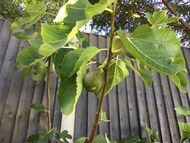
The principality had several trees: most prominently two Malus domesticas (apple trees) of the Granny Smith cultivar—one of which, named New Finland Monument, was a former national monument Grade 2-listed by the NERM—two Olea europaea (olive trees), a Pyrus (pear tree) marking the westernmost end of New Eiffel Gardens and a Ficus carica (fig tree). The hedgerows forming portions of the New Eiffel–United Kingdom North and South borders consisted of several trees and shrubs within a close proximity to one another. New Eiffel also had two tree stumps; a Pyrus separating Dead Tree Lane—to which it gives its name—and Unnamed Circle, and a Pinus (pine cone tree) fronting Unnamed Circle.
Ecology
New Eiffel emitted 5.1 tonnes of greenhouse gas emissions (CO₂) per year—below the London average of 8.1 tonnes. The government had pledged in March 2020 to lower its carbon footprint, which it achieved by improving the insulation of the Main Building, regularly encouraging recycling—which it had done since 3 October 2018—and implementing low energy lighting. However, the principality's position near a motorway in the surrounding United Kingdom meant that the level of air pollution was largely dependent on actions taken by the British. The micronation's Air Quality Index score generally ranged between a low of 6–49, rated "Good", and a high of 50–59, rated "Moderate." This was an above average air quality for London. New Eiffel had signed (though did not ratify) the Sough Convention on Global Climate Change, 2019 in October 2019, which encouraged micronational action towards climate change, pollution and negative human interactions with the environment.
Human geography

Land use
237.1 square metres (38.3 percent) of land in New Eiffel was reserved for public spaces, such as the Rugbull Field, New Eiffel Gardens and Seat Square—the only public square in the micronation. This was born out of necessity due to the micronation's intensely limited territory. Roughly 211 (34.1 percent) square metres were reserved for urban use—Jimbo's Gym; New Eiffel School; the Main Building; and a privately-owned shed in Új Repülő. XCUT Therapy Parking, serving XCUT Therapy in the Main Building, alone accounted for 94 square metres of that number. Less than 2.36 square metres (0.3 percent) of land was reserved for farming. The remaining 168 square metres (27.3 percent) consisted of the transportation network—mostly the alleyways and cycle roads.
Cities
Cities were administrative divisions which possessed their own city council and limited powers of self-governance, similar to a municipality. New Eiffel had three such cities—the largest and only permanently populated—five—New Leeds; Plitvice; and the capital Új Repülő. Because of the small size of the principality, the three cities covered all of New Eiffel's landmass and de facto acted as provinces. All three cities were founded at the same time under different names in early January 2018, in the Republic of New Finland—a distant predecessor state to New Eiffel. New Leeds was known as Smithington, Plitvice as Smithton, and Új Repülő as Hardwork Village Outback; they were all renamed by at least 8 September. By size, New Leeds was the largest city with an area of 257 m² (2,766 sq ft). Plitvice had an area of 192 m² (2,066 sq ft), and Új Repülő, the smallest city, was 173 m² (1,862 sq ft) in size.
Time zone
New Eiffel was located within the 0th meridian, thus designating it within the geographical Coordinated Universal Time (UTC) offset—UTC±00:00. New Eiffel was located 17.5 km west of the Royal Observatory in Greenwich's prime meridian, and 17.6 km west of the modern IERS Reference Meridian as maintained by the International Earth Rotation and Reference Systems Service. New Eiffel formally adopted UTC year-round on 21 September 2019, after having de facto observed Greenwich Mean Time and British Summer Time. The time zone was colloquially known as New Eiffelic Time (NET).

