Carney Island
This article does not use the correct Infobox for the topic being discussed. A list of standard infoboxes can be found at MicroWiki:MicroProject Standard Infoboxes.
The suggested template to use is {{Infobox settlement}}. |
Carney Island | |
|---|---|
| Motto: "No humans, only nature." | |
| Anthem: "Long live Flandrensis" | |
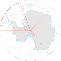
 Location in Antarctica | |
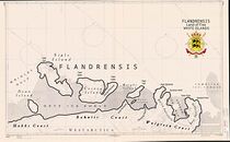
 Map of the Flandrensian islands | |
| Government | Constitutional monarchy |
• Grand Duke | Nicholas de Mersch d’Oyenberghe |
• Chancellor | Joaquin Castillo-Lopez |
| Establishment | |
• Claimed | 2009 |
| Area | |
• Total | 8.500 km2 (3.282 sq mi) |
| Population | |
• Estimate | 0 |
| Currency | Flandri |
Carney island (73 ° 57’S 121 ° 00’W) an ice-covered island, 110 km long and about 8,500 km² in area, with all but its North coast lying within the Getz Ice Shelf, Antarctica. It is located between Siple Island and Wright Island along the coast of Marie Byrd Land. Carney Island was named after Admiral Robert B. Carney (1895–1990).
Flandrensis
Claim
Flandrensis is located on five small islands of the coasts of West Antarctica: Siple Island (73 ° 39’S, 125 ° 12’W), Carney Island (73 ° 57’S 121 ° 00’W), Maher Island (72 ° 58’S 126 ° 22 ‘W), Cherry Island (73 ° 45’S 123 ° 32’W) and Pranke Island (73 ° 14’S 124 ° 55’W) and based its claim on an interpretation of the Antarctic Treaty (1959). The treaty prohibits any nation from claiming Antarctic territory between 90-150° (West-Antarctica), but the treaty didn’t mention claims by individual persons. So Nicholas claimed the islands in his personal name and sent letters to the United Nations and to the nations who signed the Antarctic Treaty to inform them of his claim, thereafter he grant his islands to the Grand Duchy. All of these countries ignored the territorial claim of Flandrensis.
Originally the island was part of the Kingdom of Finismund and negotiations on the transfer of the territory were planned in November 2009. When Finismund collapsed on 01 December 2009, Flandrensis claimed the islands nearby Siple: Maher Island, Pranke Island, Cherry Island and Carney Island. After the Scramble for Finismund, all new micronational claims in the Marie Byrd Land were regulated under the Antarctic Micronational Union.
No humans policy
The mission of Flandrensis is that Antarctica should be untouched by human activity and they strongly believe that it should remain a nature preserve only available for scientific research well beyond the expiration of the Antarctic Treaty in 2048. With the motto "No humans, ony nature" Flandrensis identify themselves as the only country in the world that doesn’t want its land inhabited by people. Since 2016 the micronation send climate letters to governments or companies who violate environmental agreements in Antarctica or who threaten the fragile eco-system (whale hunting, mining, pollution, tourism, sport events, etc.).


