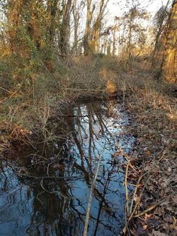
Brousailleux Bayou
Brousailleux Bayou is a bayou in the province of Algonquin in the Republic of Tueoedeth.
 Brousailleux Bayou downstream from its headwaters | |
| Location | Algonquin, Tueoedeth |
|---|---|
| Type | Creek |
| Headwaters | Tueoedeth River Island Fork |
| Mouth | Brush Run |
| Length | 331ft. (100.889 meters) |
Information
Brousailleux Bayou is a slow-moving stream categorized as a bayou located in the Tueoedethian province of Algonquin. Despite being significantly narrower than its main tributary the Tueoedeth River the Bayou drains more volume of water as it is deeper and follows a greater drop in elevation. It is believed the Bayou was channelized for former irrigation purposes around 65+ years ago. Since then the surrounding has regrown into the wooded low floodplain it once was, and the Bayou has returned to a winding path.
Course
The bayou begins at Tueoedeth River Island Fork, where a portion of the Tueoedeth River Splits off and forms the bayou. The bayou then runs beside Overlook Ridge. The bayou then turns at Graveyard Bend. After the bend, the bayou follows a straight path where Graveyard Road crosses the bayou. The stream turns right to finally reach its mouth at Brush Ditch Fork and empties into Brush Ditch.
Local Area
The greatest drop in elevation where the bayou flows is known as Spook Hollow the hollow is known to have very eerie-shaped trees and repeating land formations that can cause a visitor to the hollow to become lost. The hollow is also known to have an old pet cemetery within it. With these factors, it is a traditional belief in Tueoedeth that Spook Hollow is haunted.